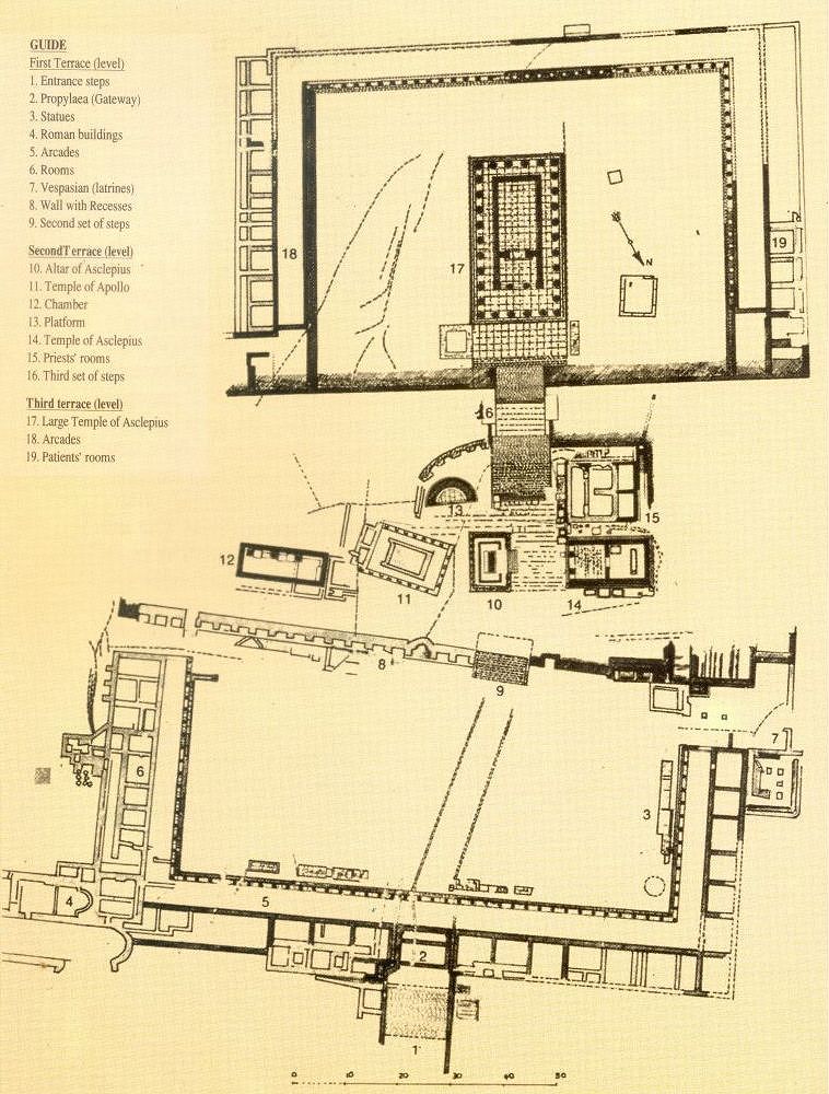
Plan of the Asklepieion of Kos.
This topographical map illustrates the architectural layout across the site’s three distinct terraces. Key features include the First Terrace with its Roman buildings and latrines, the Second Terrace containing the Altar and Temple of Apollo, and the Third Terrace dominated by the Large Temple of Asklepios.
Based on the primary survey by P. Schazmann and R. Herzog in Kos: Ergebnisse der deutschen Ausgrabungen und Forschungen (1932). This specific rendering is adapted from M.S. Kiapokas, Hippocrates of Cos and the Hippocratic Oath, Athens 1999.
◈ ◈ ◈
Ελληνική Περιγραφή
Κάτοψη του Ασκληπιείου της Κω.
Αυτός ο τοπογραφικός χάρτης απεικονίζει την αρχιτεκτονική διάταξη στα τρία διακριτά άνδηρα του χώρου. Τα κύρια χαρακτηριστικά περιλαμβάνουν το Πρώτο Άνδηρο με τα ρωμαϊκά κτίρια και τις βεσπασιανές (αποχωρητήρια), το Δεύτερο Άνδηρο που περιλαμβάνει τον Βωμό και τον Ναό του Απόλλωνα, και το Τρίτο Άνδηρο όπου δεσπόζει ο Μεγάλος Ναός του Ασκληπιού.
ασισμένο στην αρχική αποτύπωση των P. Schazmann και R. Herzog στο Kos: Ergebnisse der deutschen Ausgrabungen und Forschungen (1932). Η συγκεκριμένη απόδοση προέρχεται από το έργο του Μ.Σ. Κιαπόκα, Ιπποκράτης ο Κώος και ο Ιπποκρατικός Όρκος, Αθήνα 1999.
Schazmann, P., & Herzog, R. (1932). Kos: Ergebnisse der deutschen Ausgrabungen und Forschungen. Band I: Asklepieion. Wellcome Collection (Digital Archive). https://wellcomecollection.org/works/xt4nwsuc
Altar Apollo Asklepieion Asklepieion of Kos Athens Kos Island Map Roman Temple Temple of Apollo