Archaeological Map of Ancient Kassope
Kassope, Epirus
4th century BCE – 21st century CE
Late Classical – Hellenistic Era (Modern Signage)
Informational Signage
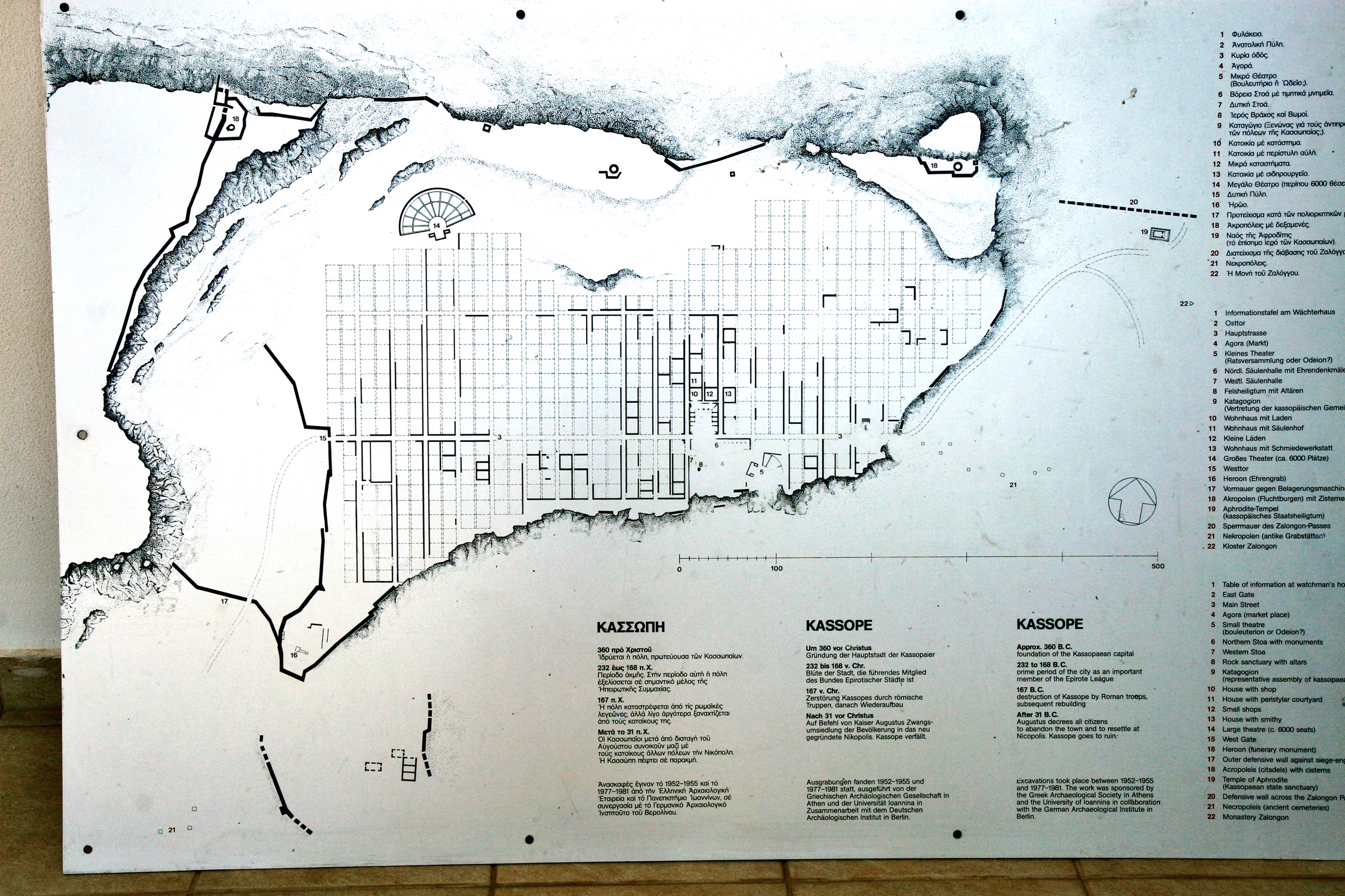
Topographic plan of the city plateau and its urban grid.
This master plan illustrates the sophisticated urban design of Ancient Kassope. The city was laid out on a natural limestone plateau, utilizing a strict Hippodamian grid of 19 horizontal and 60 vertical streets. The plan highlights the strategic zoning of the city: the Agora and public buildings like the Katagogion and North Stoa occupy the center, while the Great Theatre is integrated into the natural slope to the northwest. Surrounding the urban grid, the heavy fortification walls trace the irregular edge of the cliffs, demonstrating a perfect fusion of rigorous mathematical planning and practical mountain defense.
◈ ◈ ◈
Αρχαιολογικό Σχέδιο της Αρχαίας Κασσώπης
Το γενικό αυτό σχέδιο απεικονίζει τον εξελιγμένο πολεοδομικό σχεδιασμό της Αρχαίας Κασσώπης. Η πόλη εκτείνεται σε ένα φυσικό ασβεστολιθικό πλάτωμα, χρησιμοποιώντας ένα αυστηρό Ιπποδάμειο σύστημα με 19 οριζόντιους και 60 κάθετους δρόμους. Το σχέδιο αναδεικνύει τη στρατηγική χωροταξία της πόλης: η Αγορά και τα δημόσια κτίρια, όπως το Καταγώγιο και η Βόρεια Στοά, καταλαμβάνουν το κέντρο, ενώ το Μεγάλο Θέατρο είναι ενσωματωμένο στη φυσική κλίση στα βορειοδυτικά. Περιμετρικά του αστικού ιστού, τα βαριά οχυρωματικά τείχη ακολουθούν την ακανόνιστη γραμμή των βράχων, αποδεικνύοντας μια τέλεια σύζευξη αυστηρού μαθηματικού σχεδιασμού και πρακτικής ορεινής άμυνας.
Kassope Archaeological Site. Preveza, Epirus, Greece. Photographed on location in 2013. ◈ Αρχαιολογικός χώρος Κασσώπης. Πρέβεζα, Ήπειρος, Ελλάδα. Φωτογράφηση 2013.