Ancient Greece Map: Illustrated Highlights
Aegean and Eastern Mediterranean
3,000,000 BCE–30 BCE
Archaic, Classical, Hellenistic
Digital Illustration
Cartographic representation of cultural and historical milestones
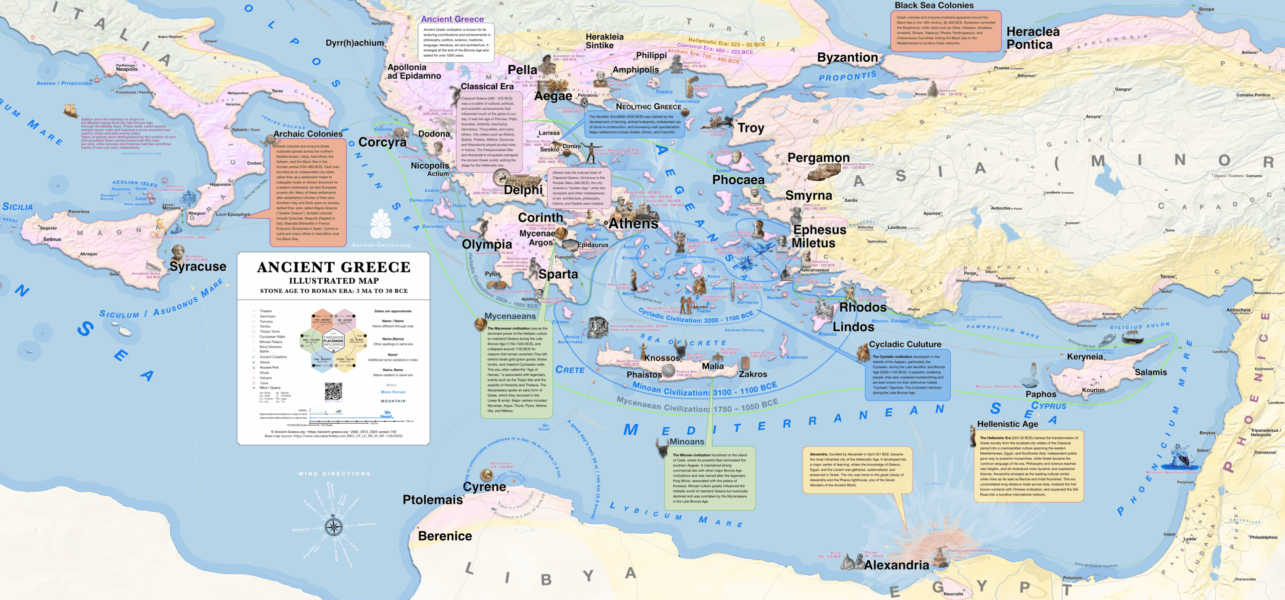
This map provides a comprehensive visual synthesis of Ancient Greece, detailing significant milestones from the Stone Age through the Hellenistic period. The visualization utilizes illustrated highlights to identify major archaeological sites, urban centers, and cultural monuments that defined the development of the Aegean basin. Chronological transitions are indicated through distinct cartographic layers, spanning the Archaic and Classical eras until the Roman annexation in 30 BCE. Designed to encapsulate the bare essentials of the Greek world, the map serves as an effective wall poster for classrooms, academic environments, and private rooms. This resource is provided free of charge to facilitate educational access to Mediterranean history.
The cartography incorporates a dense layer of biographical and cultural data, situating major personalities such as Pericles, Thucydides, Herodotus, Aeschylus, Phidias, Plato, Aristotle, and Archimedes at their respective birthplaces. It further identifies the provenance of renowned works of art and maps significant mythological events at their traditional locations. Beyond cultural history, the map provides technical data on Greek colonization, sea routes, and prevalent winds, alongside shipwrecks and a visibility horizon to establish a human scale of the landscape. Each location features an embedded timeline, offering a diachronic perspective on the evolution of civilizations within the region. This comprehensive resource is available in both English and Greek.
◈ ◈ ◈
Χάρτης της Αρχαίας Ελλάδας: Εικονογραφημένα Σημαντικά Σημεία
Αιγαίο και Ανατολική Μεσόγειος
3.000.000 π.Χ.–30 π.Χ.
Αρχαϊκή, Κλασική, Ελληνιστική
Ψηφιακή Εικονογράφηση
Χαρτογραφική αναπαράσταση πολιτιστικών και ιστορικών οροσήμων
Ο παρών χάρτης είναι διαθέσιμος και στα Ελληνικά.
Directory | Κατάλογος
Database with the index of every place on the map with additional spellings and information.
◈ Βάση δεδομένων με το ευρετήριο κάθε τοποθεσίας στον χάρτη, με επιπλέον γραφές και πληροφορίες.
Sources | Πηγές
General map sources may be found in the bibliography.
◈ Γενικές πηγές βρίσκονται στη βιβλιογραφία.
Aegean Archaic Art Bronze Age Classical Hellenistic Map Original Map Original Photo Roman Stone Age Thucydides