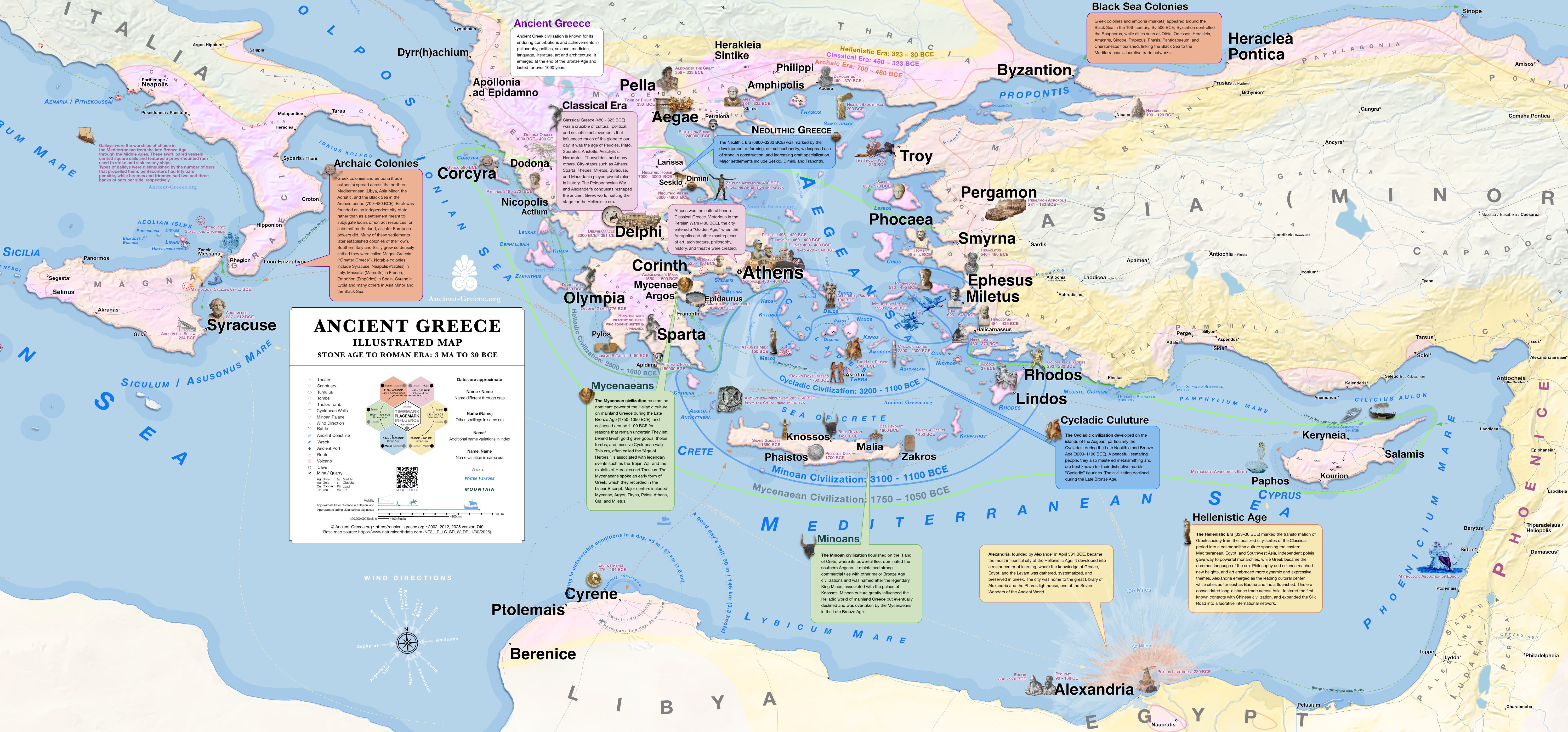
Detailed Map of Ancient Greece
Stone Age to Roman Era: 3 Ma – 30 BCE

Detailed map of the Ancient Greece
Λεπτομερής Χάρτης της Αρχαίας Ελλάδας
Our most detailed and complete in area coverage map of Ancient Greece includes every place in the map index, from the Stone Age to the Roman Era, each hand-pinned after verification with trusted sources (also see the bibliography). In English and Greek.
PDF: Zoom x10, Search, Print 138.89 × 62.5 inches (352.78 × 158.75 cm). Printing note: Anything smaller than full size will have text too small to read.
Contents:
Index of places & sources
The database contains the directory of over 1700 settlements with additional names and sources for each.
Editor’s notes
Information on the map elements, design, and styles.
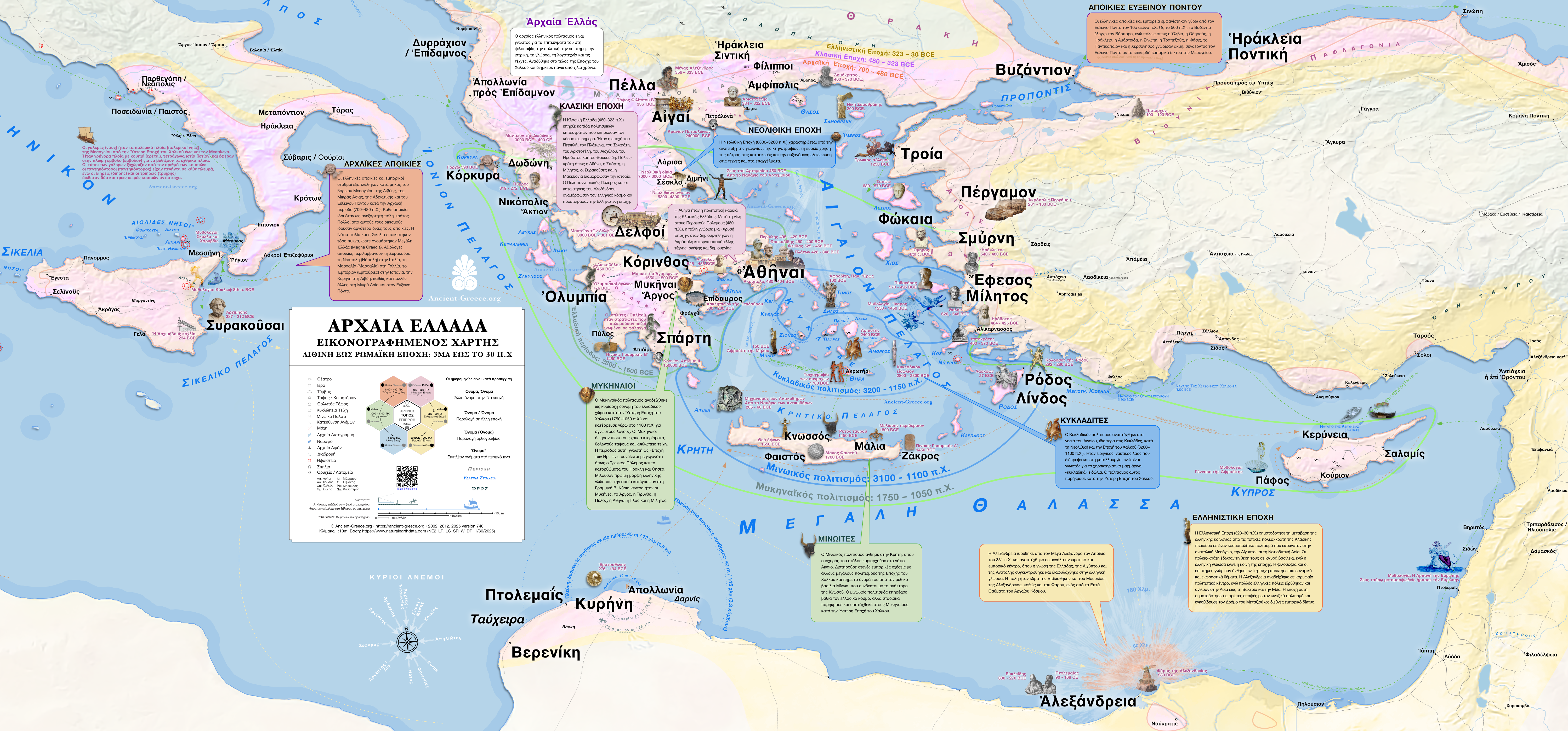
Illustrated Map of Ancient Greece
Stone Age to Roman Era: 3 MA – 30 BCE
In English: Illustrated Map of Ancient Greece
In Greek: Εικονογραφημένος Χάρτης της Αρχαίας Ελλάδας.
3 MA to 30 BCE
PNG: Zoom x4, Print 41.64 × 19.43 inches (105.76 × 49.35 cm)
Satellite View
3 MA ~ 200 CE
Ancient Greece Settlements Working File on Google Maps
Ancient Greece Settlements Working File on Google Earth
| Multiple eras | Stone Age | Bronze Age | Dark/Archaic Age | Classical Age | Hellenistic Age | Late Hellenistic / Roman |
 |  |  |  | |  |  |
| 8000 – 3000 BCE | 3000 – 1000 BCE | 1000 – 480 BCE | 480 – 323 BCE | 323 – 146 BCE | 146BCE+ |
Abridged Editions

Original files:
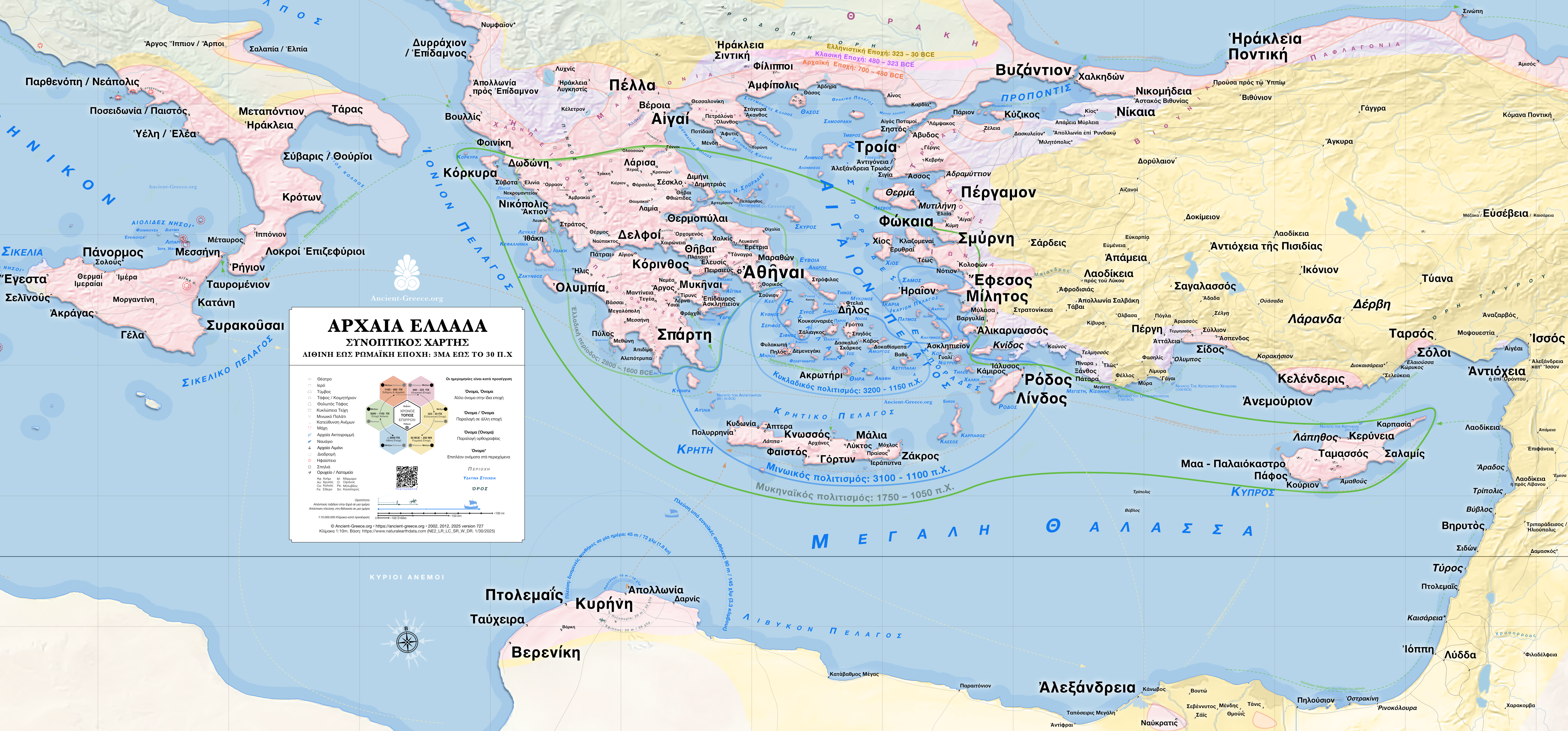
Detailed Map of Ancient Greece
Λεπτομερής Χάρτης της Αρχαίας Ελλάδας
3 MA to 30 BCE
PNG: Zoom x4, Print 41.64 × 19.43 inches (105.76 × 49.35 cm)
Original files:
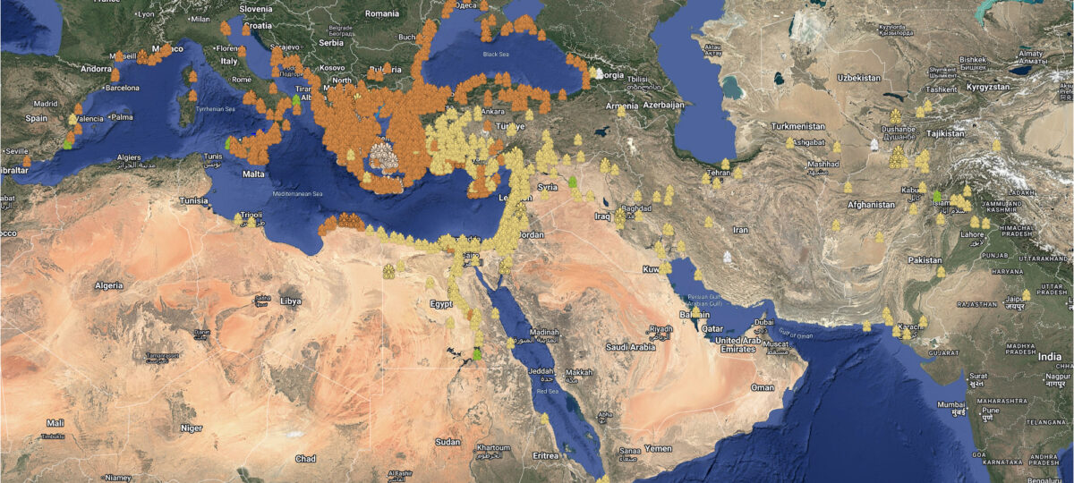
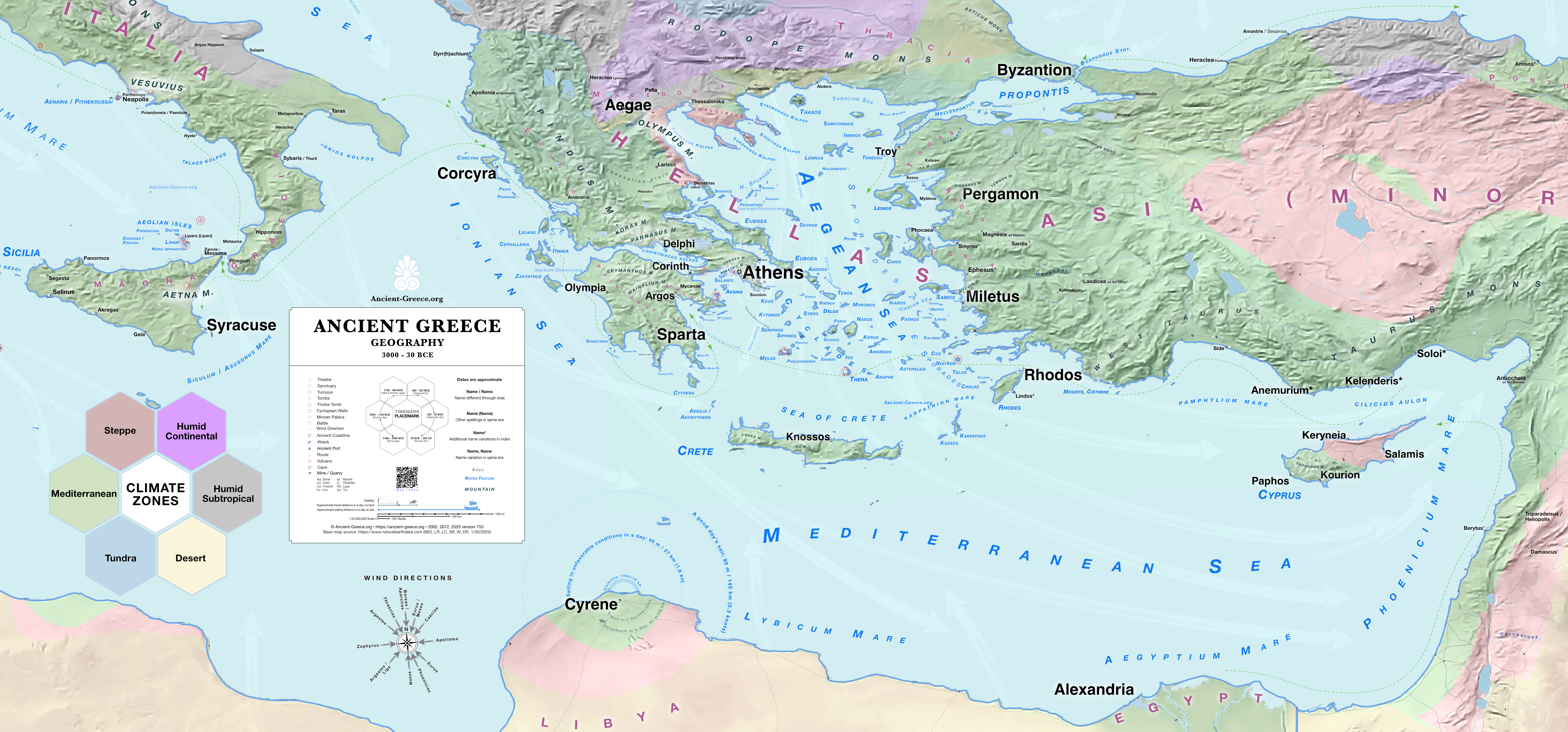
Geography
3000 to 30 BCE
.
PNG: Zoom x4, Print 41.64 × 19.43 inches (105.76 × 49.35 cm)
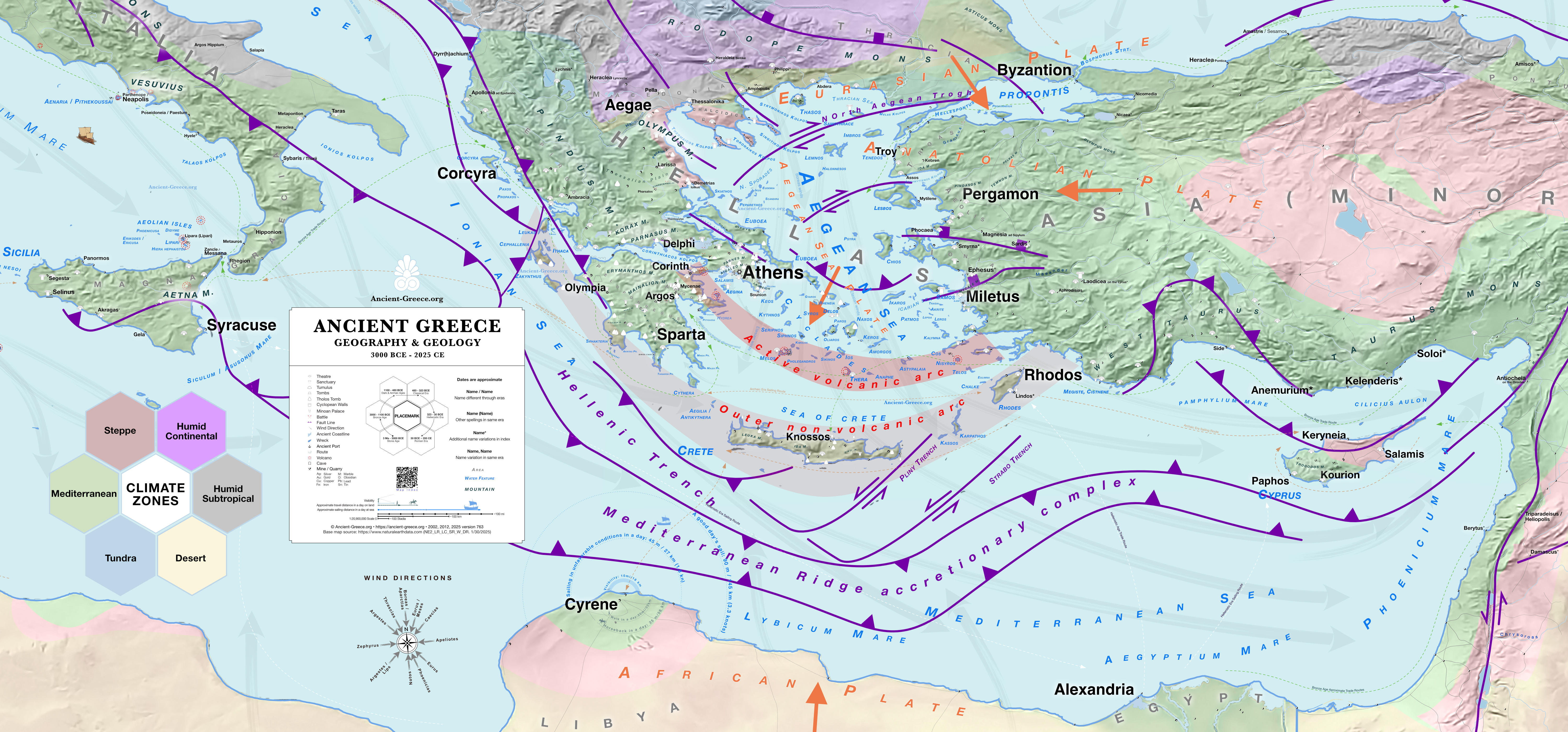
Original files:
Geography and Geology
3000 BCE to 2025 CE
.
PNG: Zoom x4, Print 41.64 × 19.43 inches (105.76 × 49.35 cm)
Original files:
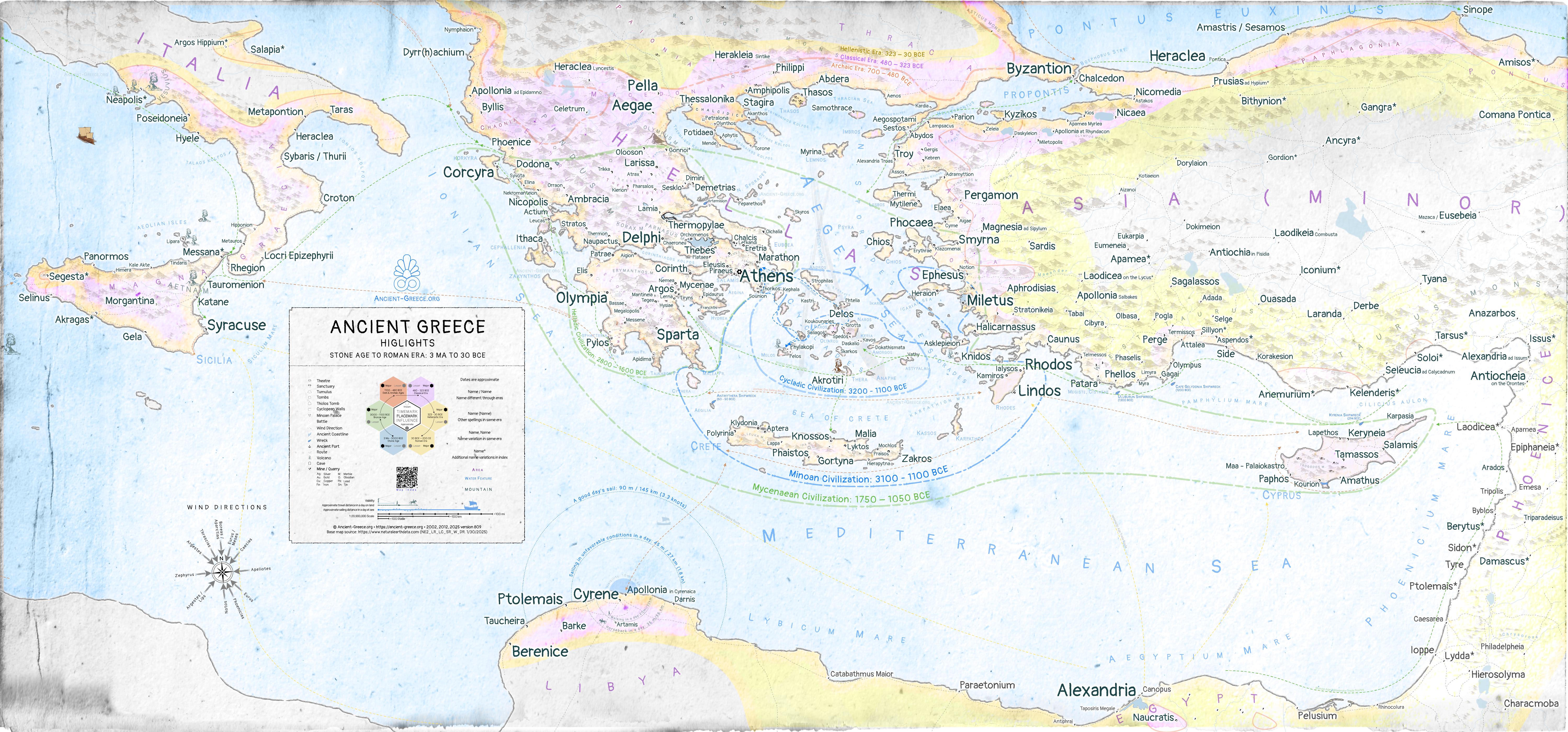
Highlights
Συνοπτικός χάρτης της Αρχαίας Ελλάδας
3 MA to 30 BCE
PNG: Zoom x4, Print 41.64 × 19.43 inches (105.76 × 49.35 cm)

Original files:
Stone & Bronze Ages: Cycladic, Minoan, Helladic, and Mycenaean civilizations
Λίθινη, και Εποχή του Χαλκού: Κυκλαδικός, Μινοϊκός, Ελλαδικός, και Μυκηναϊκός Πολιτισμός
3MA to 1100 BCE
PNG: Zoom x4, Print 41.64 × 19.43 inches (105.76 × 49.35 cm)
Original files:
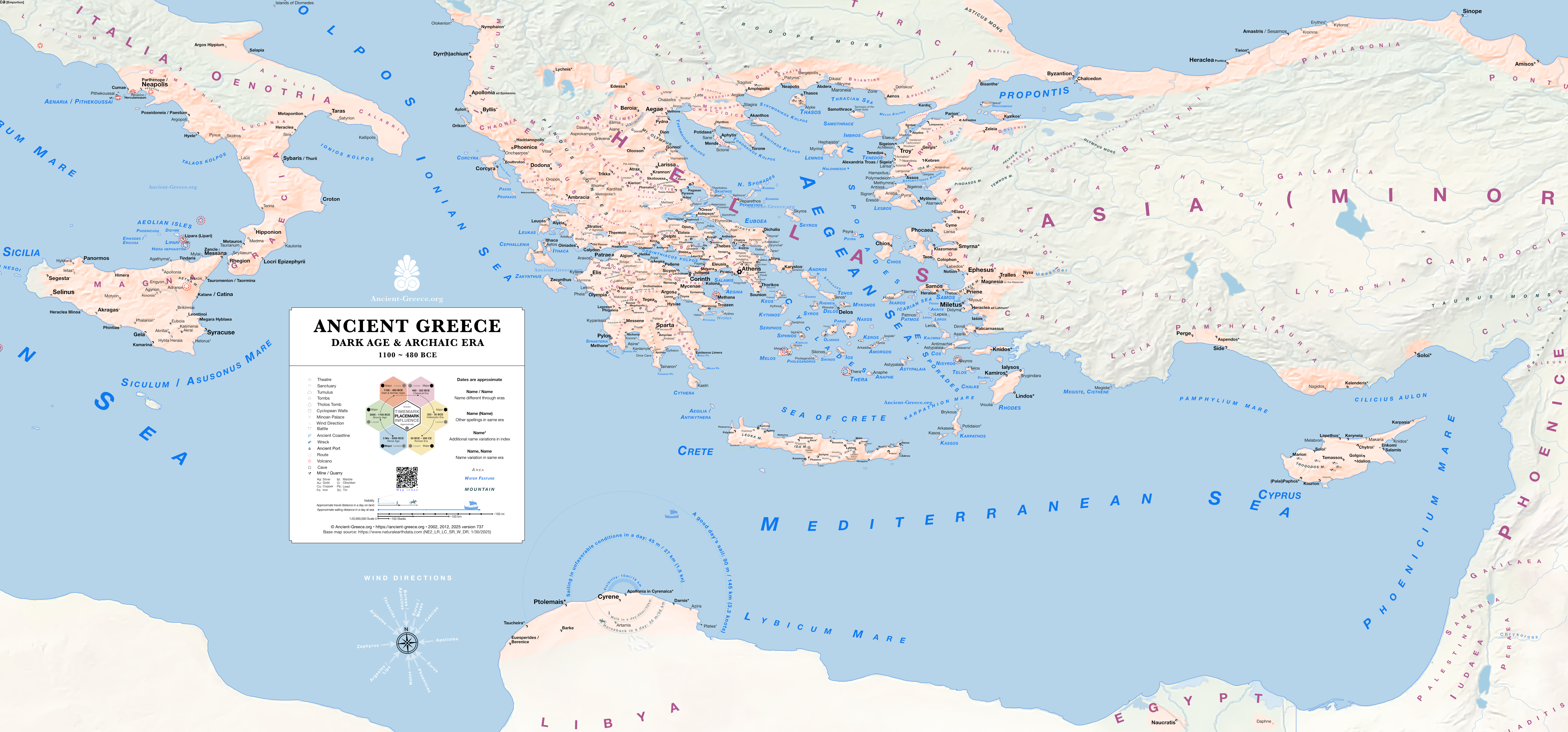
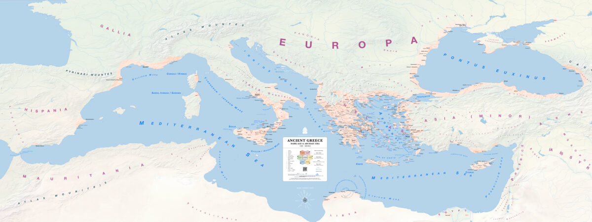
Dark Age and Archaic era Colonies
Η Αρχαία Ελλάδα κατά τον Σκοτεινό αιώνα και την Αρχαϊκή εποχή
1100 – 480 BCE
PNG: Zoom x4, Print 41.64 × 19.43 inches (105.76 × 49.35 cm)

Original files:
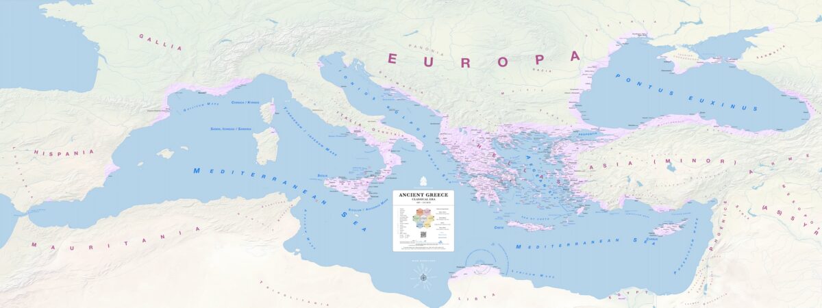
Classical Greece
Κλασική Εποχή
480 to 323 BCE
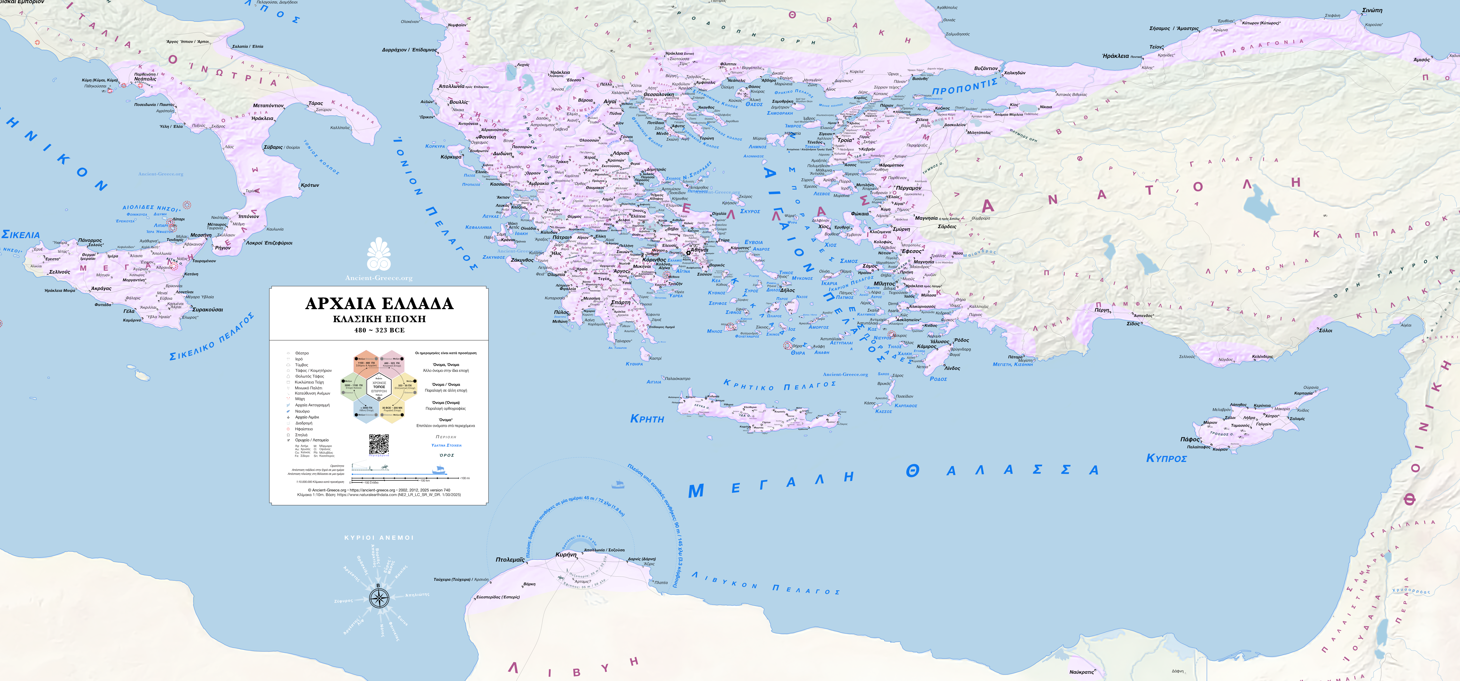
PNG: Zoom x4, Print 41.64 × 19.43 inches (105.76 × 49.35 cm)
Original files:
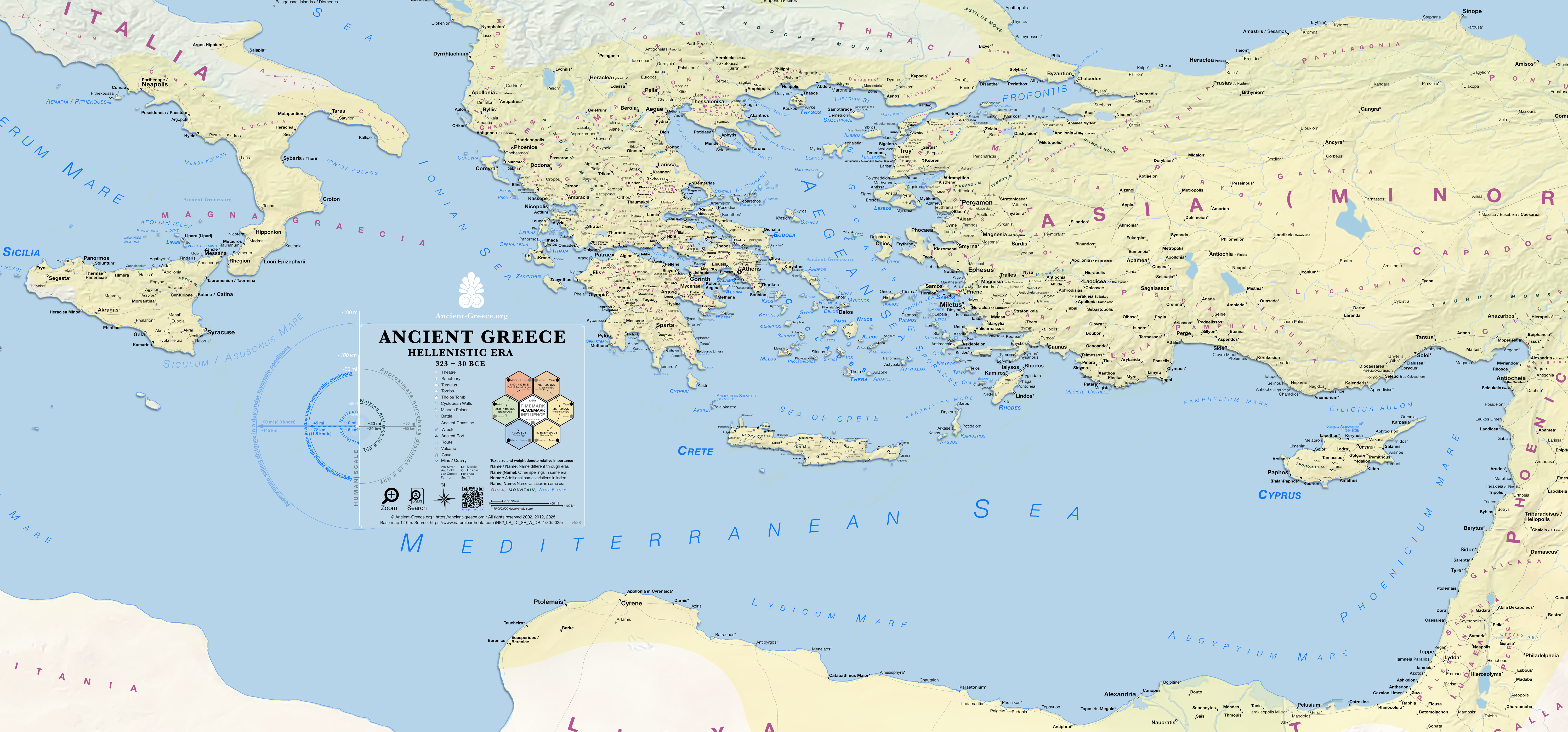
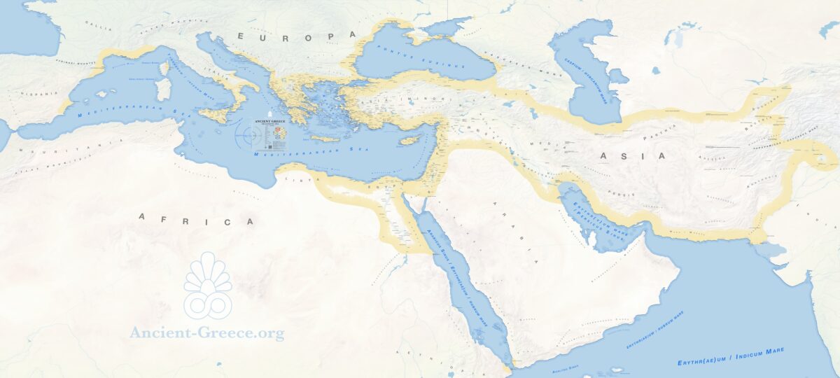
Hellenistic Era
323 BCE to 30 CE
PNG: Zoom x4, Print 41.64 × 19.43 inches (105.76 × 49.35 cm)
Map Gallery
Ancient Greece Map. Highlights. 3 Ma to 30 BCE. 
Χάρτης της Αρχαίας Ελλάδας. Συνοπτικός. Ανατολική Μεσόγειος. 3εκ-30 πΧ. 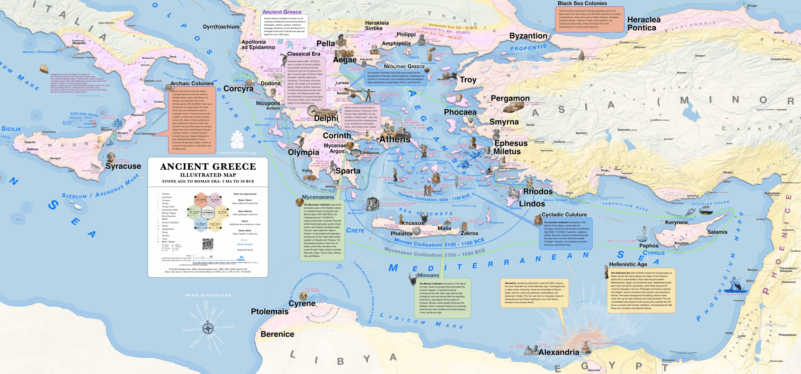
Illustrated Map of Ancient Greece. 3MA to 30 BCE. 
Εικονογραφημένος Χάρτης της Αρχαίας Ελλάδας. Ανατολική Μεσόγειος, από το 3 MA έως το 30 πΧ. 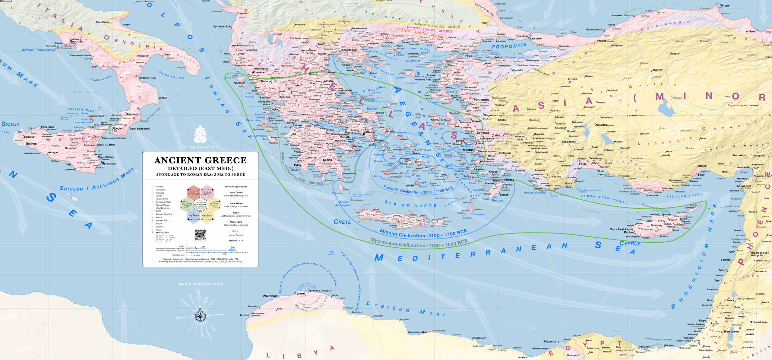
Ancient Greece Map. Detailed (East Med) 3.5M to 30 BCE. 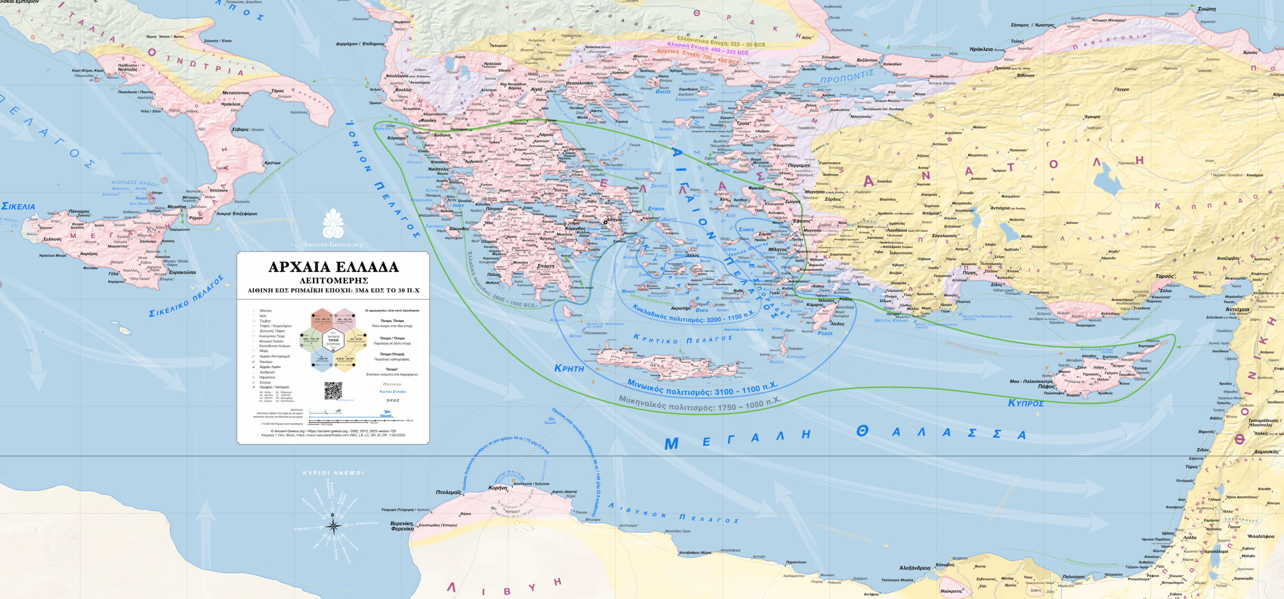
Λεπτομερής Χάρτης της Αρχαίας Ελλάδας. Ανατολική Μεσόγειος. Από το 3 εκ έως το 30 πΧ 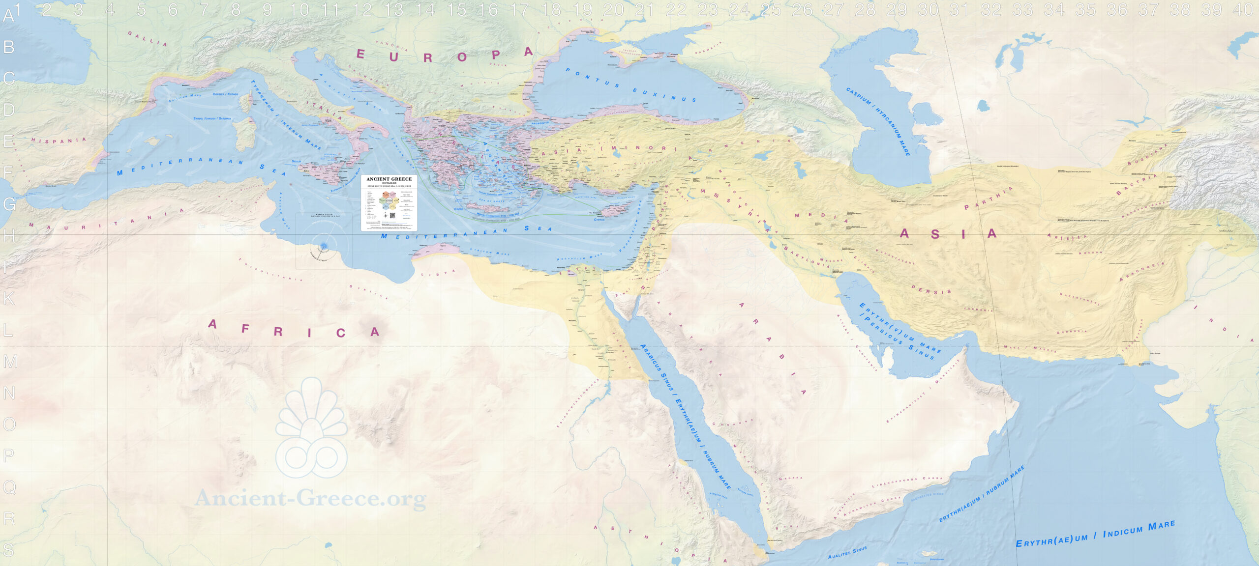
Ancient Greece Map. Complete (pre3000 to 30 BCE). 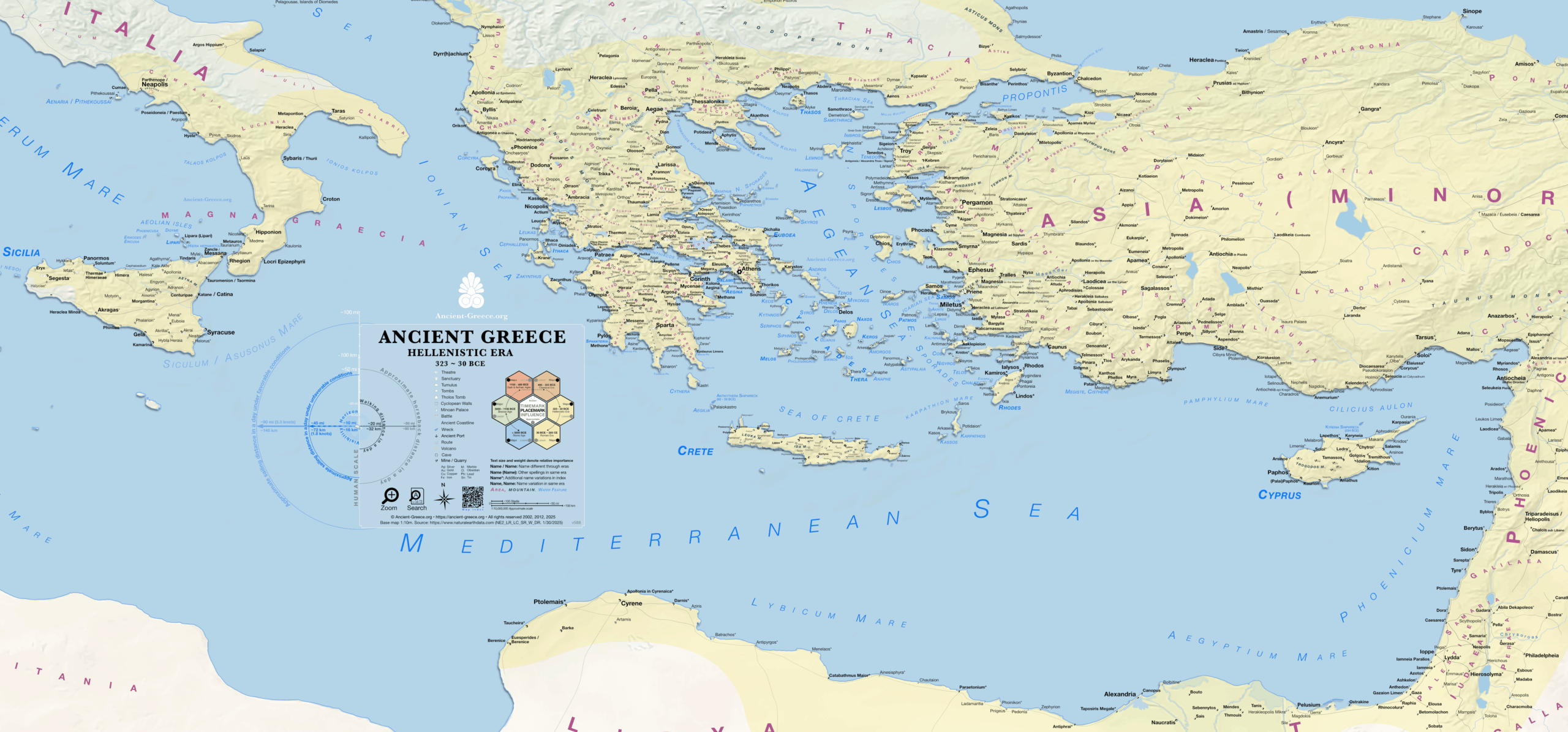
Ancient Greece Map: All the settlements of the Hellenistic Era (323 to 30 BCE) around the Eastern Mediterranean. 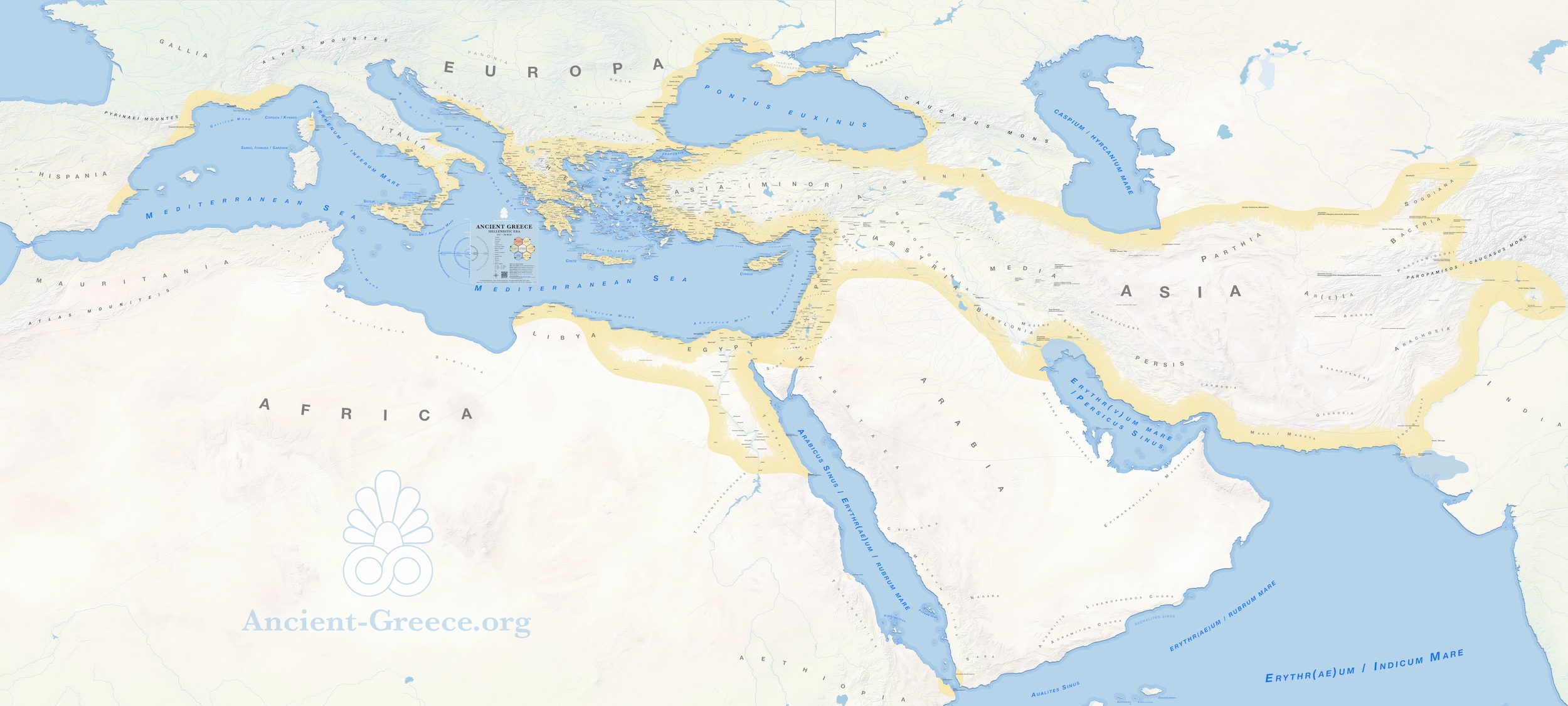
Ancient Greece Map. Hellenistic Era (323 to 30 BCE). 
Ancient Greece Map: The Classical Era (480 to 323 BCE). Partial map centered on the Eastern Mediterranean. 
Χάρτης της Αρχαίας Ελλάδας κατά την Κλασική Εποχή. 480 εως το 323 πΧ. 
Χάρτης της Αρχαίας Ελλάδας κατά την Κλασική Εποχή. 480 εως το 323 πΧ. 
Ancient Greece Map Dark and Archaic Era 1100 to 480 BCE. 
Map of Ancient Greece During the Dark and Archaic Eras. 1100 to 480 BCE. 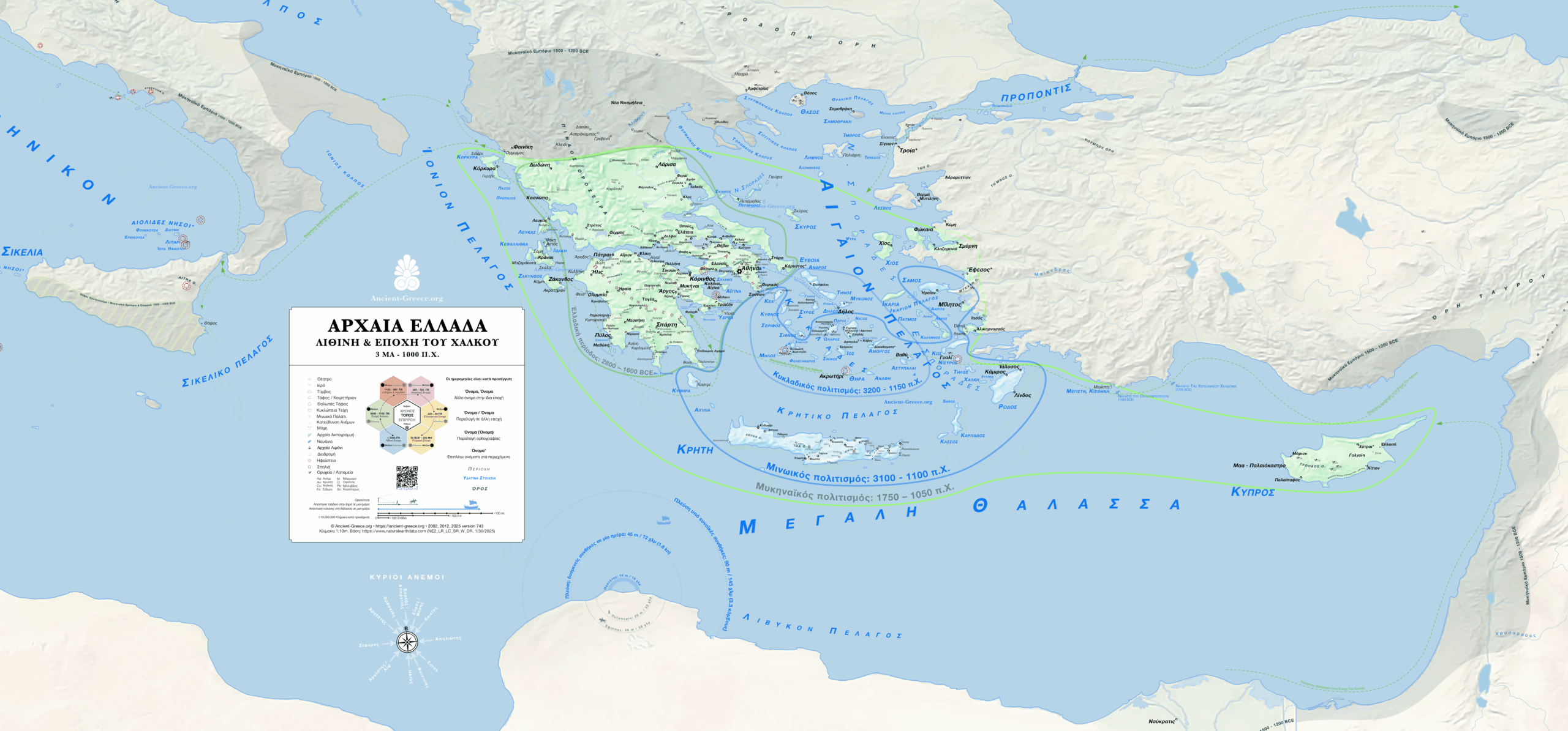
Προϊστορική Ελλάδα: Από την Παλαιολιθική στην Εποχή του Χαλκού (≈400.000−1100 π.Χ.) 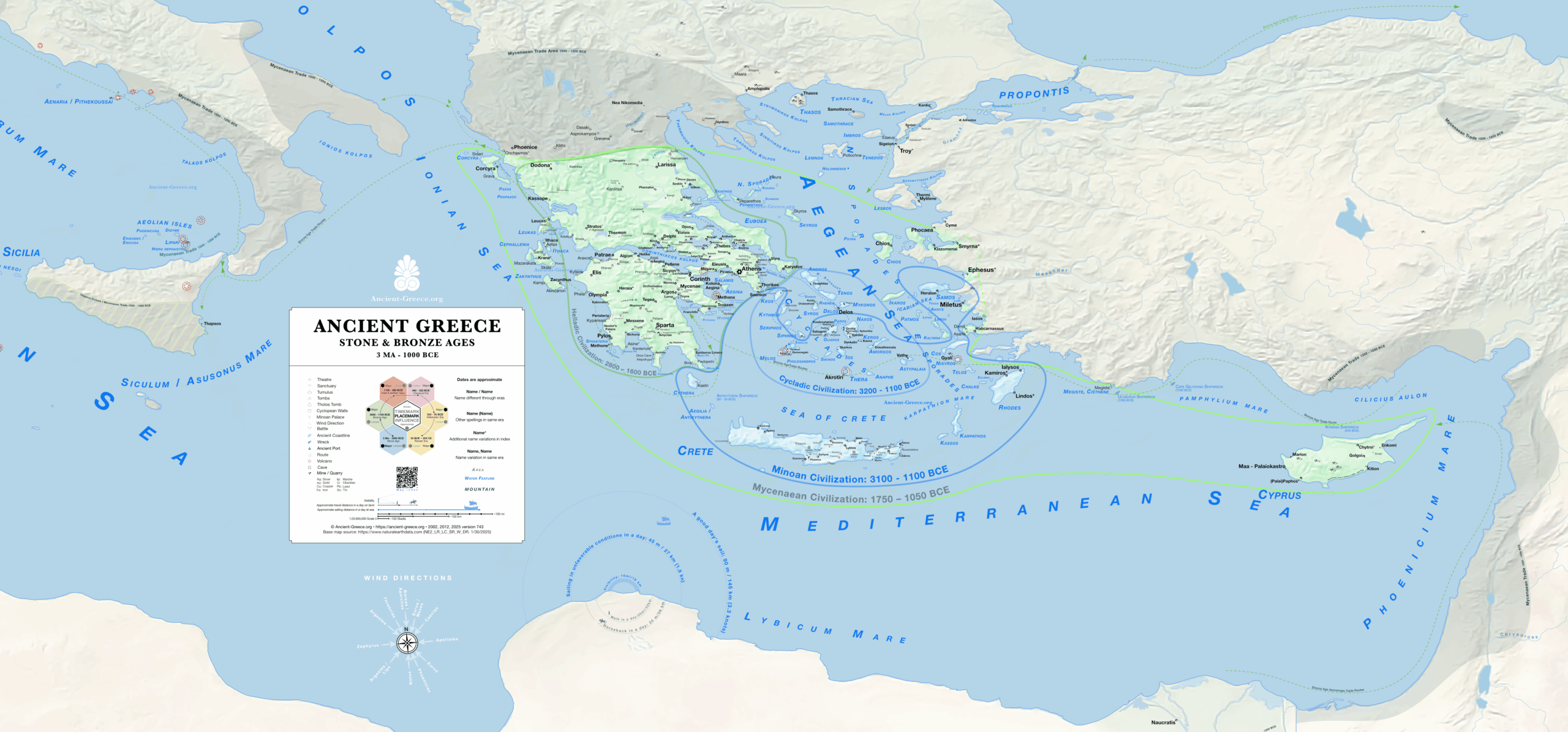
Map of Ancient Greece during the Stone and Bronze Ages. 3 MA to 1100 BCE. 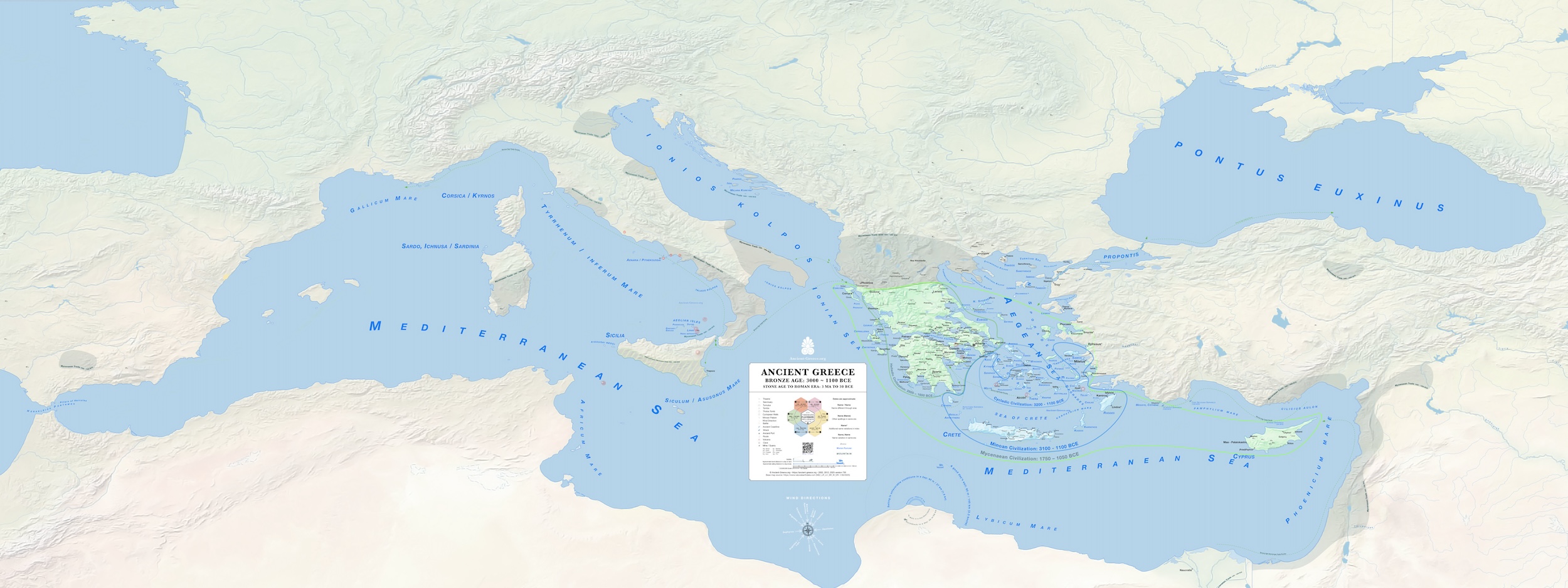
Thumbnail of Ancient Greece Map. Stone and Bronze Ag. 3 MA to 1100 BCE. 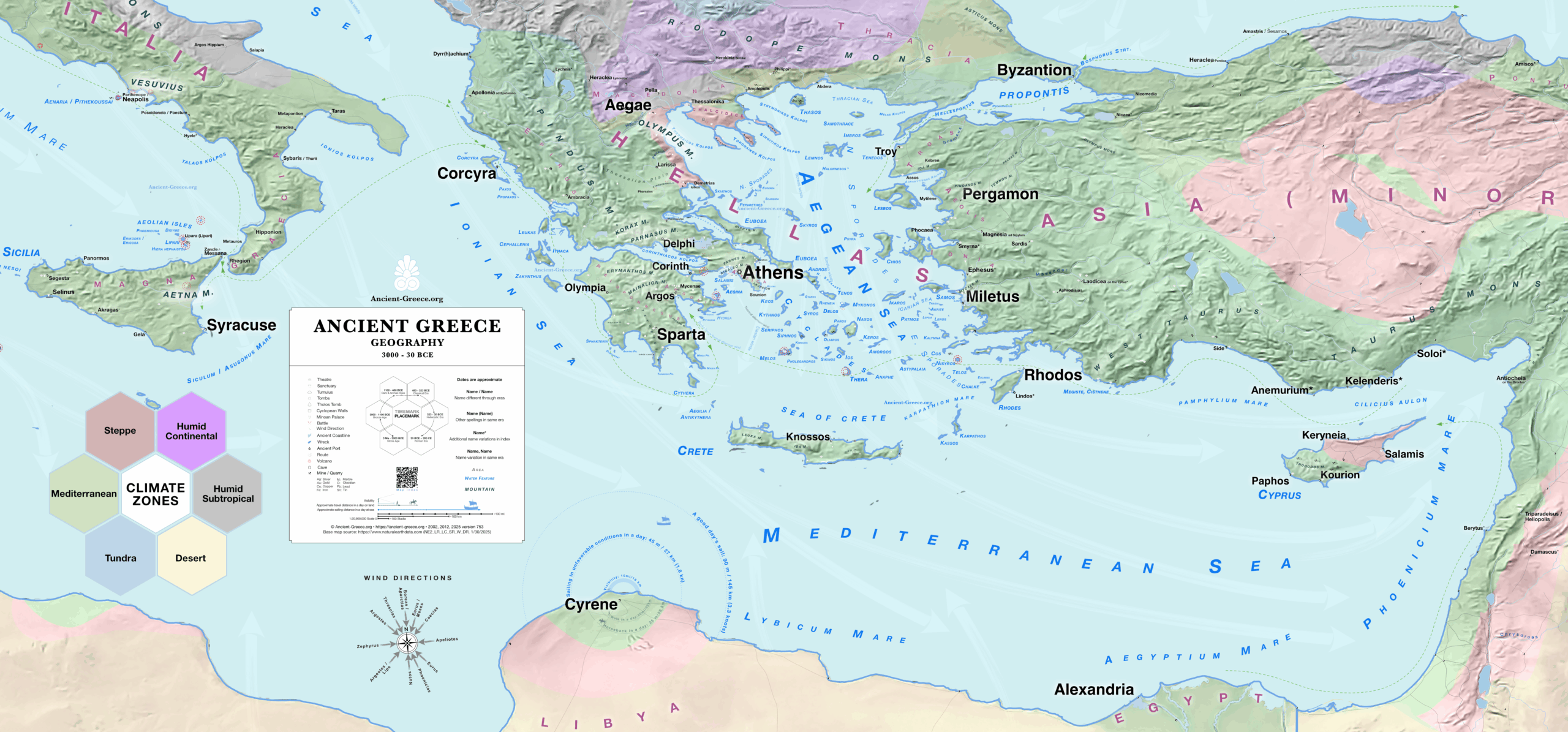
Geography of Ancient Greece. 3000 BCE to 30 BCE. 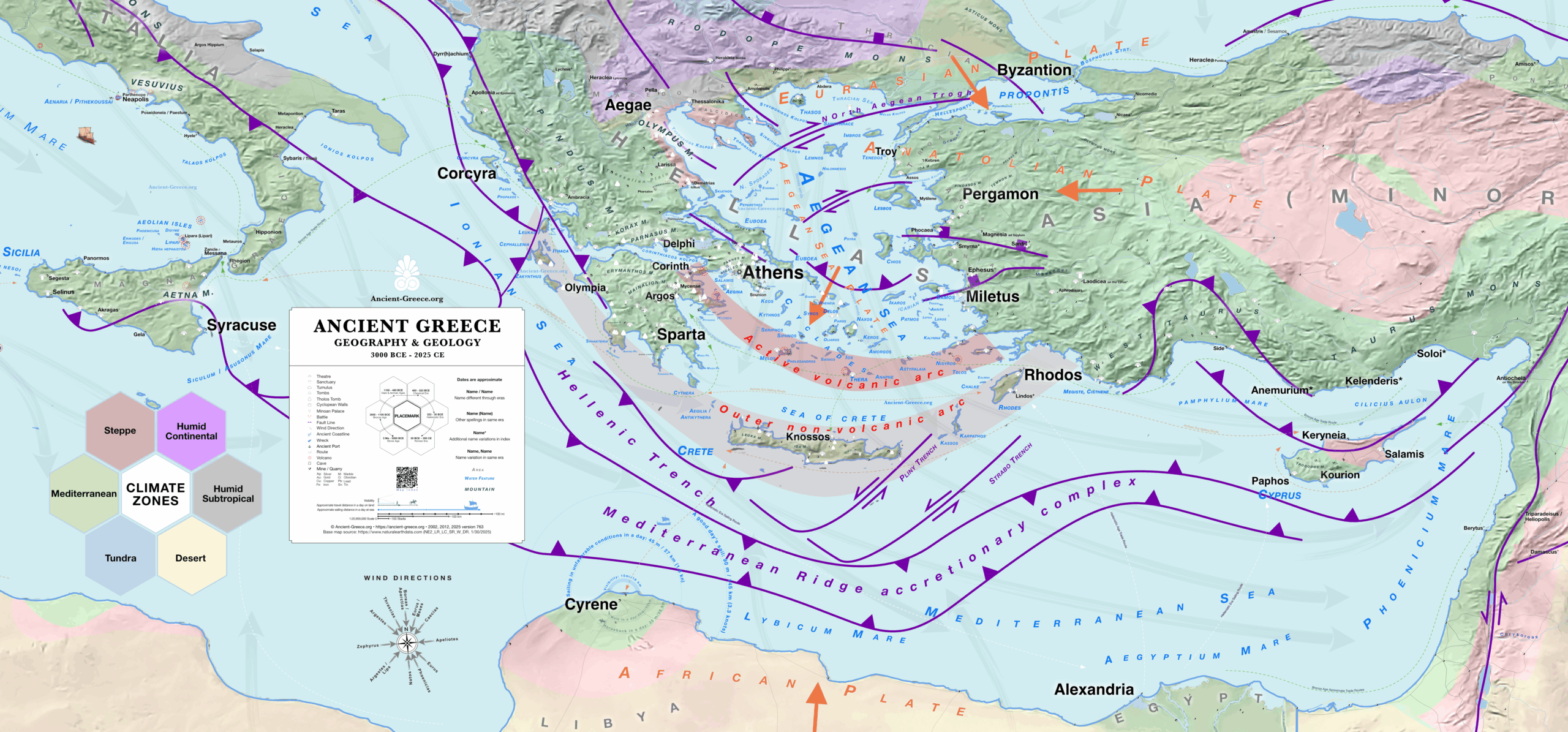
Ancient Greece – Geography and Geology – 3000 BCE to 2025 CE
This slideshow illustrates Ancient Greece through map previews.
For high quality maps and to see more details, open or download the free original files found on this page.
Detailed Maps By Era

Original files:
Stone & Bronze Age civilizations: Cycladic, Minoan, Helladic, and Mycenaean
Λίθινη, και Εποχή του Χαλκού: Κυκλαδικός, Μινοϊκός, Ελλαδικός, και Μυκηναϊκός Πολιτισμός
3 Ma to 1100 BCE
PDF: Zoom x10, Search, Print 83.34 × 31.25 inches
211.68 × 79.37 cm
Original files:
Dark Age and Archaic Era Colonies
Σκοτεινη και Αρχαϊκή Εποχή
1100 – 480 BCE
.
.
PDF: Zoom x10, Search, Print 83.34 × 31.25 inches
211.68 × 79.37 cm
Original files:
Classical Greece
Κλασική Εποχή
480 to 323 BCE
.
.
PDF: Zoom x10, Search, Print 83.34 × 31.25 inches
211.68 × 79.37 cm
Original files:
Hellenistic Era
Ελληνιστική Εποχή
323 BCE to 200 CE
.
PDF: Zoom x10, Search, Print 138.89 × 62.5 inches
352.78 × 158.75 cm
About
The work’s scope is to create a comprehensive and thorough map of Ancient Greece that includes all known and probable locations that is, informative, accurate, and visually pleasing both in print and digital screens.
In the process, each place on the map was reviewed and verified with trusted sources (Map index, Bibliography).
Development began in 2002, and the project reached its maturity in 2025, in version 400, with a new base map and 99% of settlements verified and pinned.
The maps include places which were predominantly settled by Greeks, or were centers of Greek influence, or Hellenized, or administered by Greeks, from the Stone Age to the Roman Era (pre-3000 BCE to about 200 CE).
The Detailed • Complete map of Ancient Greece includes every major and minor settlement in the index. It describes Greek Civilization’s expanse from Spain to India, and from the Black Sea to Egypt, starting from the depths of the Stone Age and ending in Late Antiquity. Shaded areas and colored outlines approximate each historical period’s widest expansion. They are not “borders” or “empires”.
For the most part, the visual design pays homage to the old primary school wall maps and geography textbooks from the late 20th century, but some thematic maps feature experimental styles.
These maps integrate the author’s research on Ancient Greece and information design. They are constructed through a meticulous process: designing the base map, surveying the landscape for historical data, and manually plotting each location one dot at a time.
Therefore, the map is a living document in a constant state of development, with new additions, corrections, and amendments presented in each version.
Version numbers are located in the map legend.
These exclusive maps are free for personal use, but reproduction, remixing, embedding, translating, or publication in any form or media, sale, or relicensing is not allowed. Read more about appropriate usage