On this page:
Ελληνικά
Περιεχόμενα:
Όρραον: Το Πέτρινο Οχυρό των Μολοσσών
Ο αρχαιολογικός χώρος του Ορράου (Ὄρραον), που βρίσκεται σε μια στρατηγική ασβεστολιθική ράχη κοντά στον σημερινό Γυμνότοπο Πρέβεζας, αποτελεί ένα από τα πιο αξιοσημείωτα δείγματα Κλασικής και Ελληνιστικής πολεοδομίας στην Ήπειρο.
Ιστορικό Πλαίσιο και Στρατηγική Ίδρυση
Ιδρύθηκε τον 4ο αιώνα π.Χ. (μεταξύ 385 και 370 π.Χ.) επί βασιλείας του Μολοσσού βασιλιά Αλκέτα Α’. Η τοποθεσία επιλέχθηκε με στρατιωτική ακρίβεια για να ελέγχει το κύριο πέρασμα από τον Αμβρακικό Κόλποπρος το λεκανοπέδιο των Ιωαννίνων. Το 167 π.Χ., ο Ρωμαίος ύπατος Λεύκιος Αιμίλιος Παύλος κατέστρεψε την πόλη στο πλαίσιο της καθυπόταξης της Ηπείρου. Ο ιστορικός Λίβιος (History of Rome, 45.26) αναφέρει το Όρραον ως Horreum, μία από τις λίγες πόλεις που προέβαλαν αντίσταση πριν παραδοθούν. Παρόλο που ο οικισμός ξαναχτίστηκε, εγκαταλείφθηκε οριστικά μετά το 31 π.Χ., όταν ο Αύγουστος ανάγκασε τους κατοίκους να εγκατασταθούν στη Νικόπολη.
Πολεοδομία και Οικιστική Αρχιτεκτονική
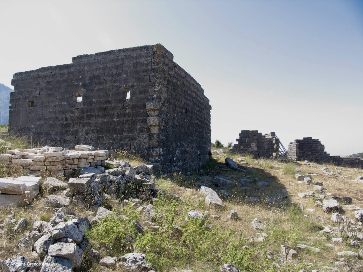
Το Όρραον αποτελεί πρότυπο ελληνικής πολεοδομίας, επηρεασμένο από το σύστημα της γειτονικής Αμβρακίας. Ο οικισμός αποτελούνταν από 100 σπίτια χτισμένα από τοπικό ασβεστόλιθο, οργανωμένα σε έναν αυστηρό ιστό. Δώδεκα παράλληλοι στενοί δρόμοι, πλάτους 2,50 έως 3,50 μέτρων με κατεύθυνση Β-Ν, διασταυρώνονταν με δύο φαρδύτερους δρόμους, σχηματίζοντας ορθογώνιες οικοδομικές νησίδες πλάτους 15 μέτρων. Σε μια μοναδική διάταξη, μια μεμονωμένη οικία καταλάμβανε συνήθως ολόκληρο το πλάτος της νησίδας. Η εξαιρετική διατήρηση των λίθινων κατοικιών επιτρέπει στον θεατή να δει τοίχους που φτάνουν το ύψος του δευτέρου ορόφου, με ορατά πλαίσια παραθύρων, παραστάδες θυρών και οπές δοκών για τα ενδιάμεσα ξύλινα πατώματα. Η απουσία δημόσιων χώρων, όπως αγοράς, υπογραμμίζει τον καθαρά αμυντικό και οικιστικό χαρακτήρα του οχυρού.
Υποδομές και η Δημόσια Δεξαμενή
Η διαχείριση του νερού ήταν ζωτικής σημασίας για τον οικισμό, λόγω της έλλειψης φυσικών πηγών στον λόφο. Η Δημόσια Δεξαμενή, στο βορειοανατολικό και υψηλότερο σημείο της πόλης, αποτελεί άριστο δείγμα υδραυλικής μηχανικής. Πρόκειται για μια ορθογώνια κατασκευή, εν μέρει λαξευμένη στον βράχο και επενδεδυμένη με ασβεστολιθικούς δόμους. Οι μελετητές την κατατάσσουν ως αρυκρήνη, όπου το νερό αντλούνταν με τη βύθιση δοχείων. Για λόγους υγιεινής, ένας πέτρινος περίβολος ύψους περίπου 3 μέτρων περιέβαλλε τον χώρο, εμποδίζοντας τη ρύπανση και ελέγχοντας την πρόσβαση. Μια λίθινη κλίμακα στη βορειοανατολική γωνία επέτρεπε τον καθαρισμό του πυθμένα και τη λήψη νερού καθώς η στάθμη μεταβαλλόταν κατά τη διάρκεια του έτους.
Αρχαιολογική Έρευνα
Οι πρώτες ανασκαφές ξεκίνησαν το 1972 από την Ιουλία Βοκοτοπούλου, τότε διευθύντρια της ΙΒ’ Εφορείας Κλασικών Αρχαιοτήτων. Η συστηματική έρευνα συνεχίστηκε μεταξύ 1975 και 1981 από το Πανεπιστήμιο Ιωαννίνων υπό τη διεύθυνση του Σ. Δάκαρη, σε συνεργασία με το Γερμανικό Αρχαιολογικό Ινστιτούτο, εστιάζοντας στην ανασκαφή της Οικίας 1 (γνωστής ως Οικία Α). Αυτές οι έρευνες προσέφεραν τα στοιχεία για τις αναπαραστάσεις των πολυώροφων κατοικιών και επιβεβαίωσαν τον ρόλο της τοποθεσίας ως κορυφαίου παραδείγματος ορεινής οχυρής αρχιτεκτονικής στην Αρχαία Ελλάδα.
Orraon: The Stone Stronghold of the Molossians
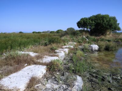
The archaeological site of Orraon (Ancient Greek: Ὄρραον), situated on a strategic limestone ridge near the modern village of Gymnotopos in Preveza, stands as one of the most remarkable examples of Classical and Hellenistic urban planning in Epirus. Unlike many ancient cities reduced to their foundations, Orraon is defined by the extraordinary preservation of its private residences, many of which still stand two stories high.
Photographs – Φωτογραφίες
More photos – περισσότερες φωτογραφίες …
Historical Context and Strategic Foundation
Founded in the 4th century BCE (specifically between 385 and 370 BCE) during the reign of the Molossian king Alcetas I, Orraon served as a vital mountain stronghold for the Molossoi. Its location was chosen with military precision to guard the primary passage leading from the Ambracian Gulf to the Ioannina Basin, a critical trade and military corridor. In 167 BCE, the Roman consul Lucius Aemilius Paullus destroyed the city as part of the wider pacification of Epirus following the Third Macedonian War. According to the historian Livy (History of Rome, 45.26), Orraon—referred to as Horreum—was one of the few defiant cities that briefly resisted a Roman siege before being forced to surrender. Although the settlement was rebuilt shortly after the Roman destruction, it was ultimately abandoned after 31 BCE. Following the Battle of Actium, Augustus forced the inhabitants to resettle in his newly founded “Victory City,” Nicopolis.
Urban Planning and “The City of Houses”
Orraon is a masterclass in organized Greek urbanism, heavily influenced by the grid plan of nearby Ambracia. The settlement consisted of approximately 100 houses built of local light gray limestone, arranged in a remarkably rigid grid. Twelve narrow parallel streets, averaging 2.50 to 3.50 meters in width and running in a North-South direction, were intersected by two wider streets to form rectangular oblong blocks known as insulae. In a unique architectural arrangement, a single house typically occupied the full 15-meter width of each insula. The exceptional preservation of these stone-built private dwellings allows modern observers to see walls reaching the height of the second story, complete with visible window frames, door jambs, and beam holes that once supported timber internal floors. Notably, the absence of traditional public spaces such as an agora or theater emphasizes the settlement’s strictly defensive and residential character.
Infrastructure and the Public Cistern
Water management was the lifeline of this ridge-top settlement, where natural springs were absent. The Public Cistern, located at the northeast corner—the city’s highest point—is a feat of Hydraulic Engineering. This large, rectangular tank was partially carved into the bedrock and lined with well-formed limestone blocks, featuring an interior originally coated in hydraulic plaster to prevent leakage. Scholars classify this structure as an arykrene (αρυκρήνη), a type of cistern where water is retrieved by dipping containers directly into the tank. To maintain strict hygiene, a stone enclosure wall approximately 3 meters high surrounded the yard, preventing waste from contaminating the supply and controlling access. A stone staircase in the northeast corner provided access for both cleaning the floor of the tank and retrieving water as the levels fluctuated throughout the year.
Archaeological Exploration
The first formal investigations of the site were carried out in 1972 by Ioulia Vokotopoulou, then director of the 12th Ephorate of Classical Antiquities. Systematic research continued between 1975 and 1981, when the University of Ioannina under the direction of S. Dakaris, in collaboration with the German Archaeological Institute, began the excavation of House 1 (identified as House A). These excavations provided the evidence for the multi-story reconstructions and confirmed the site’s role as a primary example of durable, mountain-adapted engineering in Ancient Greece.
Arta Archaeological Museum, Epirus
4th century BCE
Classical
Digital Print
Architecture
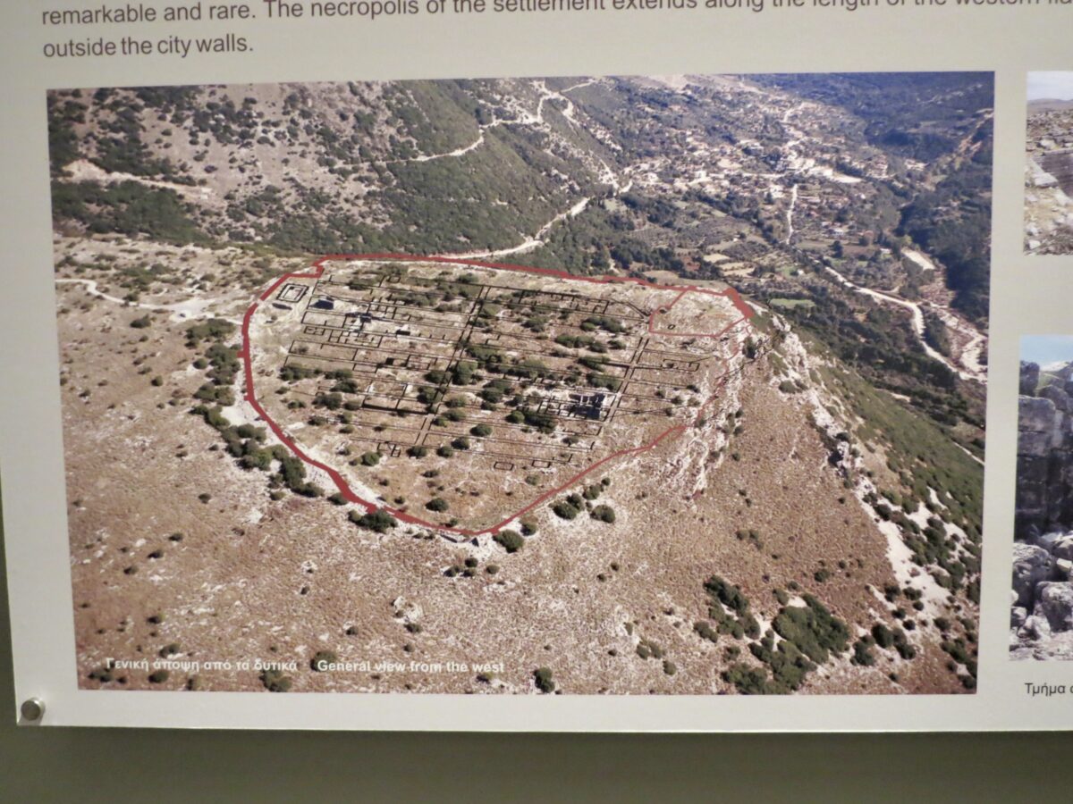
This Reconstruction, sourced from the Arta Archaeological Museum, overlays the organized city grid of Orraon onto its dramatic topographical setting. The image illustrates the settlement’s rigid urban plan, consisting of parallel streets and rectangular housing blocks that follow a calculated orientation. Positioned on a limestone ridge, the city was designed to command the vital passage connecting the Ambracian Gulf to the interior of Epirus. From this elevated plateau, the inhabitants of the Classical period enjoyed panoramic views of the surrounding valleys, allowing the Molossians to effectively monitor and control movement through the region while maintaining a highly structured civic environment.
◈ ◈ ◈
Αερογραφική αναπαράσταση του πολεοδομικού ιστού στο Όρραον
Αρχαιολογικό Μουσείο Άρτας, Ήπειρος
4ος αιώνας π.Χ.
Κλασική
Ψηφιακή Εκτύπωση
Αρχιτεκτονική
Αυτή η Αναπαράσταση, με πηγή το Αρχαιολογικό Μουσείο Άρτας, υπερθέτει τον οργανωμένο πολεοδομικό ιστό του Ορράου πάνω στο δραματικό τοπογραφικό του περιβάλλον. Η εικόνα απεικονίζει το αυστηρό αστικό σχέδιο του οικισμού, που αποτελείται από παράλληλους δρόμους και ορθογώνια οικοδομικά τετράγωνα με συγκεκριμένο προσανατολισμό. Τοποθετημένη σε έναν ασβεστολιθικό λόφο, η πόλη σχεδιάστηκε για να ελέγχει το ζωτικό πέρασμα που συνδέει τον Αμβρακικό Κόλπο με την ενδοχώρα της Ηπείρου. Από αυτό το υπερυψωμένο οροπέδιο, οι κάτοικοι της Κλασικής περιόδου απολάμβαναν πανοραμική θέα στις γύρω κοιλάδες, επιτρέποντας στους Μολοσσούς να επιτηρούν αποτελεσματικά την κίνηση στην περιοχή, διατηρώντας παράλληλα ένα εξαιρετικά δομημένο αστικό περιβάλλον.
Arta Archaeological Museum, Epirus
4th century BCE
Classical
Ink on Paper
Architecture
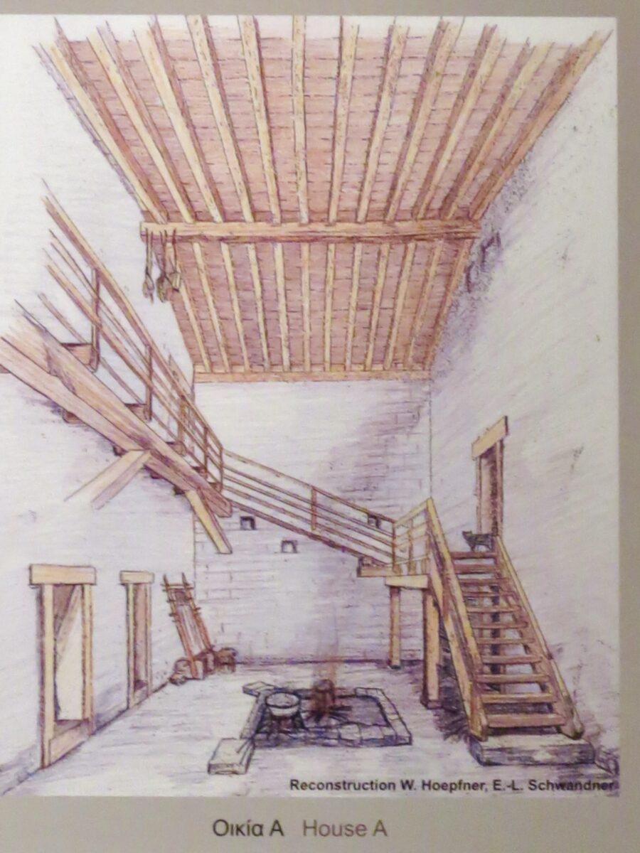
This Reconstruction of House A at Orraon, sourced from the Arta Archaeological Museum, provides a detailed look at the domestic Architecture of the Molossians. The drawing illustrates how the stone walls, which survive to remarkable heights at the site, supported a multi-story timber internal structure. A central hearth is shown on the ground floor, while a wooden staircase leads to an upper gallery and living quarters. The horizontal beam holes documented in the ruins are shown here as functional sockets for the heavy wooden joists that carried the upper floors. This image clarifies the transition from the rugged limestone Masonry seen in the field to a fully realized, two-story Classical home in Epirus.
◈ ◈ ◈
Αναπαράσταση της Οικίας Α στο Όρραον
Αρχαιολογικό Μουσείο Άρτας, Ήπειρος
4ος αιώνας π.Χ.
Κλασική
Μελάνη σε χαρτί
Αρχιτεκτονική
Αυτή η Αναπαράσταση της Οικίας Α στο Όρραον, με πηγή την ενημερωτική πινακίδα του Αρχαιολογικού Μουσείου Άρτας, παρέχει μια λεπτομερή ματιά στην οικιστική Αρχιτεκτονική των Μολοσσών. Το σχέδιο απεικονίζει πώς οι πέτρινοι τοίχοι, που διασώζονται σε αξιοσημείωτο ύψος στην τοποθεσία, στήριζαν μια πολυώροφη εσωτερική ξύλινη κατασκευή. Μια κεντρική εστία εμφανίζεται στο ισόγειο, ενώ μια ξύλινη σκάλα οδηγεί σε έναν επάνω εξώστη και στους χώρους διαβίωσης. Οι οριζόντιες οπές δοκών που τεκμηριώνονται στα ερείπια εμφανίζονται εδώ ως λειτουργικές υποδοχές για τις βαριές ξύλινες δοκούς που έφεραν τα επάνω πατώματα. Αυτή η εικόνα αποσαφηνίζει τη μετάβαση από την τραχιά ασβεστολιθική Τοιχοποιία που παρατηρείται στο πεδίο, σε μια πλήρως διαμορφωμένη, διώροφη Κλασική κατοικία στην Ήπειρο.