On this page:
Bronze Age Akrotiri: Architecture and Urban Design | Αρχιτεκτονική και Αστικός Σχεδιασμός
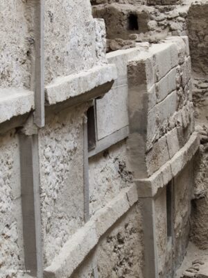
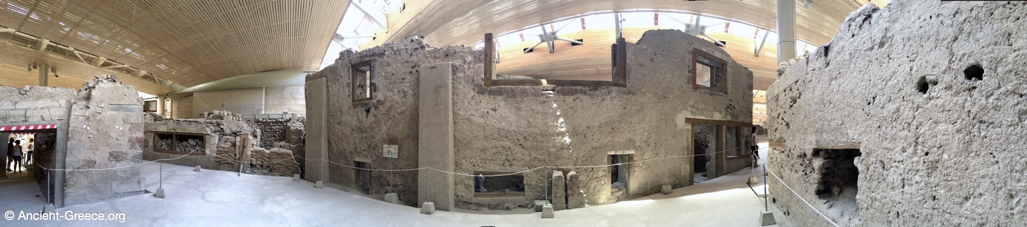
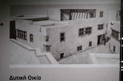
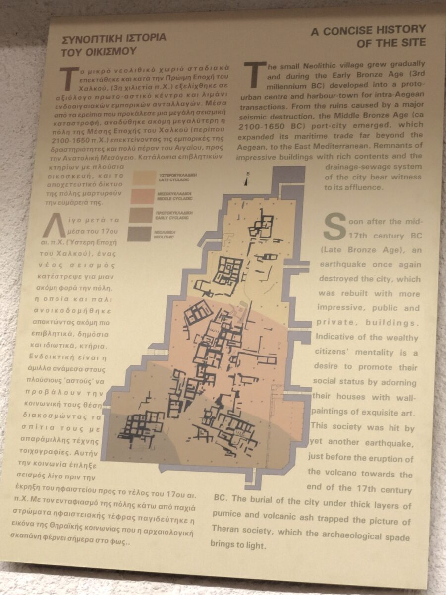
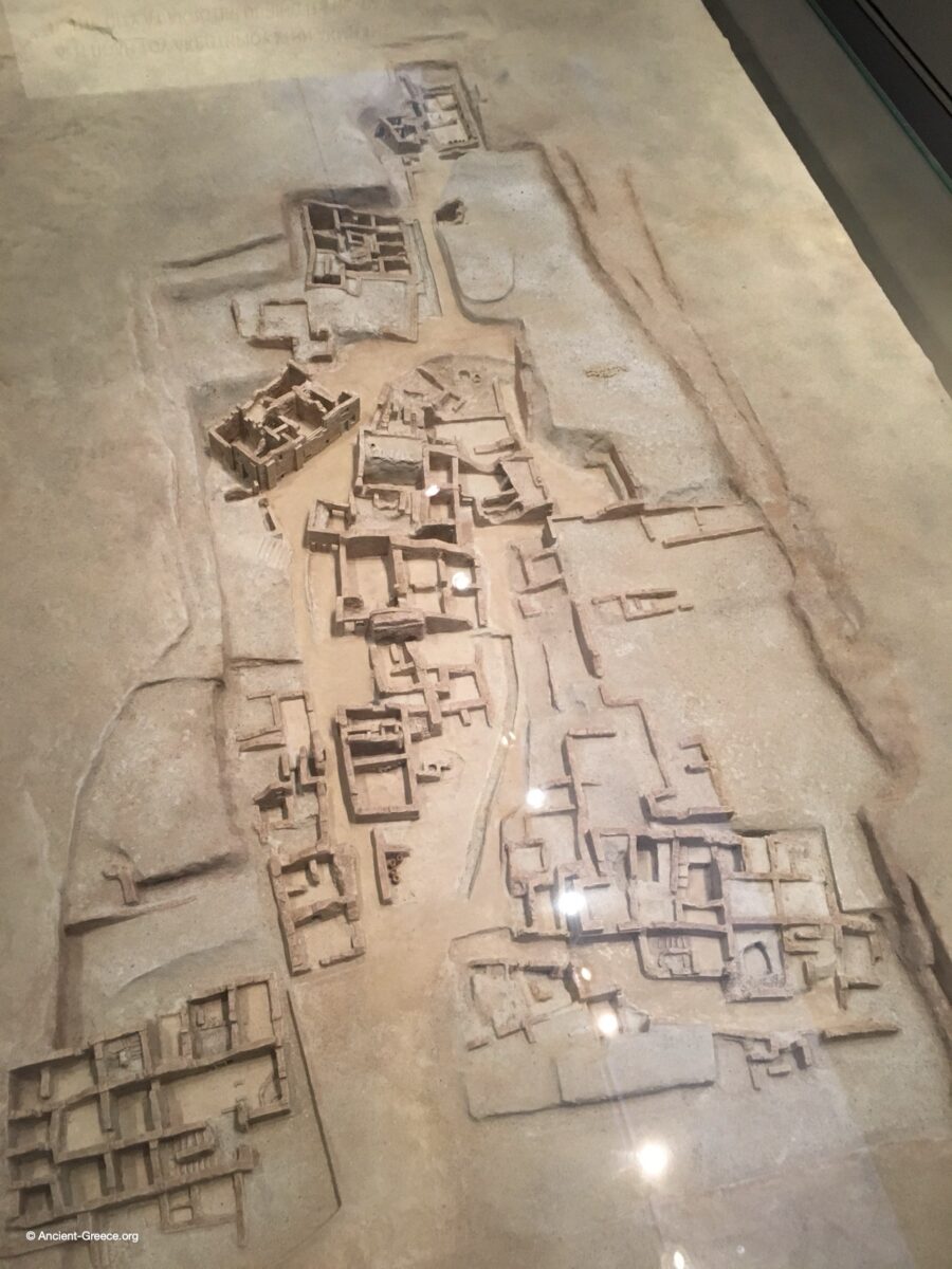
The urban planning of Akrotiri reveals a highly organized and affluent society characterized by a dense network of narrow, stone-paved streets and large public squares that served as communal hubs. Buildings typically rose two or three storeys high, constructed from mudbrick and stone, and were frequently reinforced with wooden frames to provide essential flexibility against the region’s frequent seismic activity. A hallmark of Theran engineering was the advanced sewage system, featuring clay pipes integrated directly into the walls of the houses which connected indoor sanitary facilities to a primary stone-built drain beneath the streets. This level of infrastructure, combined with the strategic separation of animal stabling outside the residential core, highlights a sophisticated understanding of urban hygiene and civil engineering that was remarkably ahead of its time.
Ο πολεοδομικός σχεδιασμός του Ακρωτηρίου αποκαλύπτει μια εξαιρετικά οργανωμένη και εύπορη κοινωνία, η οποία χαρακτηριζόταν από ένα πυκνό δίκτυο στενών, λιθόστρωτων δρόμων και μεγάλων δημόσιων πλατειών που λειτουργούσαν ως κοινοτικοί κόμβοι. Τα κτήρια ήταν συνήθως διώροφα ή τριώροφα, κατασκευασμένα από πλίνθους και πέτρα, και ενισχύονταν συχνά με ξύλινους σκελετούς για την απαραίτητη ελαστικότητα έναντι της συχνής σεισμικής δραστηριότητας. Σήμα κατατεθέν της θηραϊκήςμηχανικής ήταν το προηγμένο αποχετευτικό σύστημα, με πήλινους σωλήνες ενσωματωμένους απευθείας στους τοίχους των σπιτιών, οι οποίοι συνέδεαν τις εσωτερικές εγκαταστάσεις υγιεινής με έναν κεντρικό λιθόκτιστο αγωγό κάτω από τους δρόμους. Αυτό το επίπεδο υποδομής, σε συνδυασμό με τη στρατηγική απομάκρυνση των στάβλων έξω από τον οικιστικό πυρήνα, αναδεικνύει μια εξελιγμένη αντίληψη για την αστική υγιεινή και την πολιτική μηχανική.
Building Construction
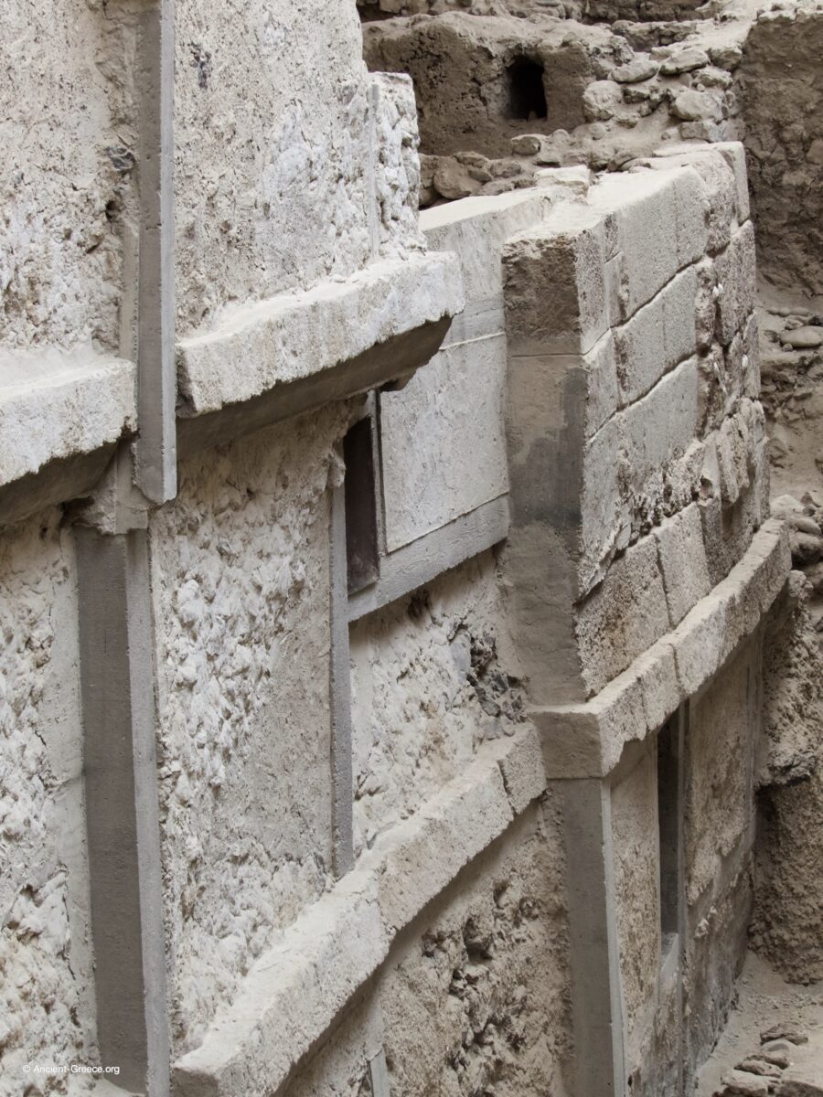
Material Composition and Binders: Research indicates that the primary binder used for the stone walls was a clay-rich earth mortar. This was not merely simple mud; it was a deliberate mixture of soil, water, and often straw or organic fibers to increase tensile strength and reduce cracking during the drying process.
- Theran Earth: The volcanic soil of the island, specifically siliceous tephra, provided a natural cementitious quality. When mixed with lime, it creates a hydraulic binder similar to later Roman pozzolana, though at Akrotiri, the primary reliance remained on high-quality clay mortars.
- Clay and Tuff: The walls utilized locally sourced volcanic tuff and andesite. The mortar filled the interstices of the stacked faces, while the core of the wall was often filled with smaller stones and more copious amounts of the earth binder.
Regional Evolution and Contemporary Parallels | Περιφερειακή Εξέλιξη και Σύγχρονα Παράλληλα
While the preservation at Akrotiri is unique, the site represents the pinnacle of a shared Aegean urban trajectory visible across several contemporary island and Cretan settlements.
The Early Cycladic prototype for this organic, terraced layout can be traced back to Skarkos on Ios, where two-story stone dwellings were already established by the third millennium BC. Similarly, Phylakopi on Melos serves as a vital commercial parallel; as a primary hub for obsidian trade, it evolved into an organized city of blocks and straight streets that eventually mirrored the Minoanized administrative order seen at Akrotiri.
On Crete, the sprawling town of Roussolakkos (Palaikastro) offers a non-palatial comparison, where wealthy merchant neighborhoods operated with high-status ashlar facades and paved roads without a central palace. Further evidence of this regional technical standard is found at Agia Irini on Kea, which featured an underground sewage network nearly identical to the Theran system, confirming that sophisticated hygiene was a hallmark of major Bronze Age maritime ports.
Αν και η διατήρηση στο Ακρωτήρι είναι μοναδική, η θέση αντιπροσωπεύει την κορύφωση μιας κοινής αιγαιακής αστικής πορείας. Το πρωτοκυκλαδικό πρότυπο αυτής της οργανικής διάταξης εντοπίζεται στον Σκάρκο της Ίου, όπου ήδη από την 3η χιλιετία π.Χ. υπήρχαν διώροφες πέτρινες κατοικίες. Η Φυλακωπή στη Μήλο αποτελεί έναν ζωτικό εμπορικό παραλληλισμό· ως κύριος κόμβος εμπορίου οψιανού, εξελίχθηκε σε μια οργανωμένη πόλη που αργότερα υιοθέτησε το μινωικό διοικητικό πρότυπο του Ακρωτηρίου. Στην Κρήτη, ο οικισμός Ρουσσόλακκος (Παλαίκαστρο) προσφέρει μια μη ανακτορική σύγκριση, με εύπορες γειτονιές εμπόρων και δρόμους με ξεστή λιθοδομή. Επιπλέον, στην Αγία Ειρήνη της Κέας, βρέθηκε ένα αποχετευτικό δίκτυο πανομοιότυπο με το θηραϊκό, επιβεβαιώνοντας ότι η εξελιγμένη υγιεινή ήταν χαρακτηριστικό των μεγάλων λιμανιών της Εποχής του Χαλκού.
From Neolithic Foundations to Middle Bronze Age Sophistication | Από τα Νεολιθικά Θεμέλια στη Σύνθεση της Μέσης Χαλκοκρατίας
To understand the architectural leap represented by Akrotiri, one must contrast it with the earlier Neolithic and Early Bronze Age centers of the Greek mainland and the northern islands. Settlements like Sesklo and Dimini in Thessaly established the first European experiments in organized living, yet they remained grounded in a defensive, megaron-centric layout characterized by concentric walls and central courtyards. While Dimini utilized a structured enclosure system, it lacked the verticality and fluid multi-story complexity seen in the later Cycladic towns. Similarly, the site of Strofilas on Andros provides a crucial precursor; as the oldest fortified city in the Aegean.
The transition from the fortified, somewhat static designs of Sesklo to the vertical, light-filled architecture of Gournia and Aghia Triada on Crete represents a shift toward “living architecture.” While Gournia shares Akrotiri’s “organic” density and winding alleyways, the Theran model refined these elements with superior sanitary engineering. In contrast to the centralized, inward-looking mainland citadels, the maritime centers of the Cyclades and the Minoan villas prioritized ventilation, internal light-wells, and a porous relationship with the harbor, signaling a society that prioritized mercantile exchange and domestic comfort over purely defensive posture.
Για να κατανοήσει κανείς το αρχιτεκτονικό άλμα του Ακρωτηρίου, πρέπει να το αντιπαραβάλει με τα παλαιότερα νεολιθικά κέντρα της ηπειρωτικής Ελλάδας. Οικισμοί όπως το Σέσκλο και το Διμήνι στη Θεσσαλία καθιέρωσαν τα πρώτα πειράματα οργανωμένης διαβίωσης, παρέμειναν όμως προσκολλημένοι σε ένα αμυντικό πρότυπο με κεντρικό μέγαρο και ομόκεντρους περιβόλους. Αν και το Διμήνι χρησιμοποίησε ένα δομημένο σύστημα περιφράξεων, στερούνταν την κατακόρυφη ανάπτυξη και την πολυπλοκότητα των μεταγενέστερων κυκλαδικών πόλεων. Αντίστοιχα, ο Στρόφιλας στην Άνδρο αποτελεί κρίσιμο πρόδρομο ως η αρχαιότερη οχυρωμένη πόλη στο Αιγαίο, αποδεικνύει ότι η οργανωμένη λιθοδομή και η κοινοτική άμυνα αναπτύσσονταν στα νησιά πολύ πριν από την ανακτορική εποχή.
Η μετάβαση από τα στατικά σχέδια του Σέσκλου στην κατακόρυφη αρχιτεκτονική της Γούρνιας και της Αγίας Τριάδας στην Κρήτη αντιπροσωπεύει μια στροφή προς την «ζωντανή αρχιτεκτονική». Ενώ η Γούρνια μοιράζεται την οργανική πυκνότητα του Ακρωτηρίου, το θηραϊκό μοντέλο την εξέλιξε με ανώτερη υγειονομική μηχανική. Σε αντίθεση με τις εσωστρεφείς ακροπόλεις της ηπειρωτικής Ελλάδας, τα ναυτικά κέντρα των Κυκλάδων και οι μινωικές επαύλεις έδωσαν προτεραιότητα στον εξαερισμό και τους φωταγωγούς, σηματοδοτώντας μια κοινωνία που ευνοούσε την εμπορική ανταλλαγή και την οικιακή άνεση έναντι της καθαρά αμυντικής στάσης.
Mediterranean Context and Architectural Legacy
Beyond the Aegean, contemporary cities in the Levant and Egypt practiced urbanism on a grander, imperial scale. The Hyksos capital at Avaris (Tell el-Dab’a) featured Minoan-style frescoes, suggesting that the “international style” seen at Akrotiri was part of a shared Mediterranean elite culture. Further east, the Syrian port city of Ugarit (Ras Shamra) shared Akrotiri’s status as a primary international trade hub, with residential quarters and sophisticated burial vaults reflecting a similarly high standard of living for the merchant class. This widespread exchange of ideas and goods underscores the role of the Cycladic people as the primary maritime connection between these diverse civilizations.
The architectural layout of Akrotiri also exhibits a striking diachronic continuity that remains visible in modern Cycladic vernacular design. The organic urban tissue was a functional response to the Meltemi winds and intense solar radiation, providing both shade and wind protection through its labyrinthine configuration. Coupled with multi-story cubic volumes and flat roofs for water collection, Akrotiri established a structural “DNA” that has persisted in the Aegean for over three millennia. Furthermore, the technical reliance on xylodesia (timber-framed masonry) highlights a long-standing adaptation to the region’s geological volatility, a method still mirrored in traditional construction throughout the Eastern Mediterranean.
Μεσογειακό Πλαίσιο και Αρχιτεκτονική Κληρονομιά
Πέρα από το Αιγαίο, σύγχρονες πόλεις στην Εγγύς Ανατολή και την Αίγυπτο εφάρμοζαν την πολεοδομία σε μια ευρύτερη, αυτοκρατορική κλίμακα. Η πρωτεύουσα των Υκσώς, Άβαρις (Tell el-Dab’a), διέθετε τοιχογραφίες μινωικού στυλ, υποδηλώνοντας ότι το «διεθνές στυλ» που παρατηρείται στο Ακρωτήριαποτελούσε μέρος μιας κοινής ελίτ κουλτούρας στη Μεσόγειο. Πιο ανατολικά, η συριακή πόλη-λιμάνι Ουγκαρίτ (Ras Shamra) μοιραζόταν με το Ακρωτήρι το καθεστώς του διεθνούς εμπορικού κόμβου, με οικιστικές συνοικίες που αντανακλούσαν ένα εξίσου υψηλό βιοτικό επίπεδο για την τάξη των εμπόρων.
Η αρχιτεκτονική διάταξη του Ακρωτηρίου παρουσιάζει επίσης μια εντυπωσιακή διαχρονική συνέχεια στη σύγχρονη κυκλαδίτικη λαϊκή αρχιτεκτονική. Ο οργανικός αστικός ιστός ήταν μια λειτουργική απάντηση στα μελτέμια και την έντονη ηλιακή ακτινοβολία. Σε συνδυασμό με τους πολυώροφους κυβικούς όγκους και τα δώματα για τη συλλογή νερού, το Ακρωτήρι δημιούργησε ένα δομικό «DNA» που επιβιώνει στο Αιγαίο για πάνω από τρεις χιλιετίες. Επιπλέον, η τεχνική της ξυλοδεσιάς αναδεικνύει μια μακροχρόνια προσαρμογή στη γεωλογική αστάθεια της περιοχής, μια μέθοδος που εξακολουθεί να αντικατοπτρίζεται στην παραδοσιακή δόμηση σε ολόκληρη την Ανατολική Μεσόγειο.
Photographs | Φωτογραφίες
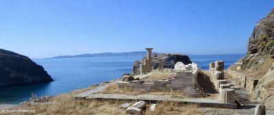
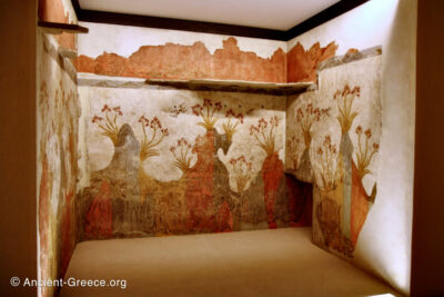
Akrotiri (Greek: Ακρωτήρι) represents one of the most significant archaeological sites in the Aegean, offering an unparalleled view of Bronze Age (3000 ~ 1100 BCE) urban life.
Located on the island of Thera (Santorini), this settlement was buried under layers of volcanic ash during the massive eruption in the 17th century BCE.
This cataclysmic event acted as a preservative, encasing the town and freezing its architecture, narrow streets, and sophisticated internal systems in a state of remarkable conservation.
Το Ακρωτήρι αποτελεί έναν από τους σημαντικότερους αρχαιολογικούς χώρους στο Αιγαίο, προσφέροντας μια απαράμιλλη εικόνα της αστικής ζωής της Εποχής του Χαλκού (3000 ~ 1100 π.Χ.).
Αυτός ο οικισμός, που βρίσκεται στο νησί της Θήρας (Σαντορίνη), θάφτηκε κάτω από στρώματα ηφαιστειακής τέφρας κατά τη διάρκεια της τεράστιας έκρηξης τον 17ο αιώνα π.Χ.
Αυτό το κατακλυσμιαίο γεγονός λειτούργησε ως συντηρητικό, εγκλωβίζοντας την πόλη και παγώνοντας την αρχιτεκτονική της, τους στενούς δρόμους και τα εξελιγμένα εσωτερικά της συστήματα σε μια κατάσταση αξιοσημείωτης διατήρησης.
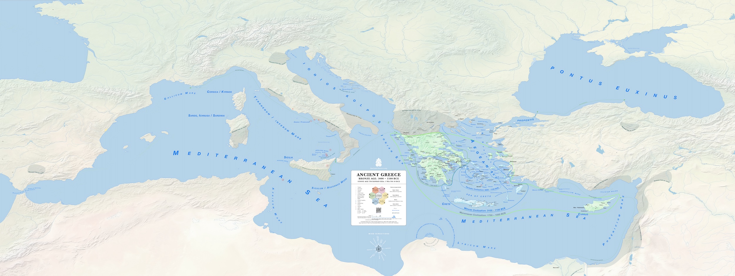
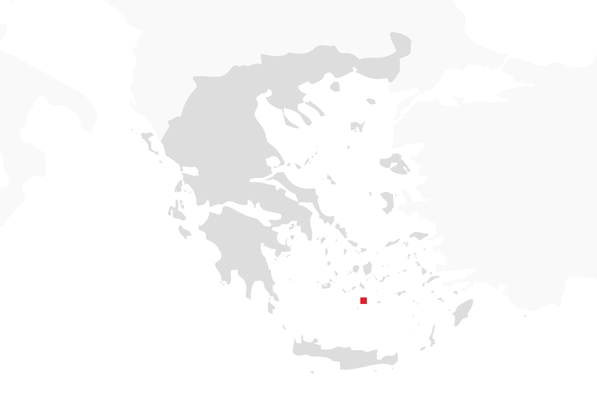
This map illustrates the central position of Akrotiri within the complex commercial networks of the Aegean during the Bronze Age. The settlement served as a primary maritime hub, facilitating trade and cultural exchange between the Cycladic islands, Minoan Crete, and the Mycenaean mainland. The cartographic data highlights the synchronous development of the Cycladic, Minoan, and Helladic civilizations during the Bronze Age.
Ο χάρτης αυτός αποτυπώνει την κεντρική θέση που κατείχε το Ακρωτήρι στα σύνθετα εμπορικά δίκτυα του Αιγαίου κατά την Εποχή του Χαλκού. Ο οικισμός λειτουργούσε ως κομβικό ναυτιλιακό κέντρο, διευκολύνοντας το εμπόριο και τις πολιτισμικές ανταλλαγές μεταξύ των Κυκλάδων, της Μινωικής Κρήτης και της Μυκηναϊκής ηπειρωτικής Ελλάδας.
Related Pages